IMAGES TAKEN NEAR TO
New Park Road, BRADFORD, BD13 2EU
Introduction
This page details the photographs taken nearby to New Park Road, BD13 2EU by members of the Geograph project.
The Geograph project started in 2005 with the aim of publishing, organising and preserving representative images for every square kilometre of Great Britain, Ireland and the Isle of Man.

There are currently over 7.5m images from over14,400 individuals and you can help contribute to the project by visiting https://www.geograph.org.uk
Image Map (Loading...)


Getting Data...Please wait
Leaflet Map data © OpenStreetMap
Images are licensed for reuse under creativecommons.org/licenses/by-sa/2.0
Notes
- Clicking on the map will re-center to the selected point.
- The higher the marker number, the further away the image location is from the centre of the postcode.
Image Listing (181 Images Found)
Images are licensed for reuse under creativecommons.org/licenses/by-sa/2.0
Image
Details
Distance
2
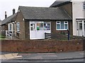
Queensbury Police & Community Contact Point - New Park Road
Image: © Betty Longbottom
Taken: 27 Dec 2008
0.02 miles
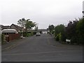
7
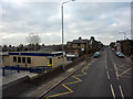
West End (A647) outside Russell Hall Primary School, Queensbury
The main (Victorian) school buildings are out of shot to the left. From the sign outside, I think that the prefabricated building houses the Out of School Club.
Image: © Phil Champion
Taken: 1 Feb 2012
0.05 miles
9
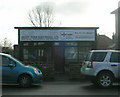
Geoff Todd Electrical Ltd - West End
Image: © Betty Longbottom
Taken: 2 Nov 2009
0.06 miles