IMAGES TAKEN NEAR TO
Briggs Villas, BRADFORD, BD13 2EP
Introduction
This page details the photographs taken nearby to Briggs Villas, BD13 2EP by members of the Geograph project.
The Geograph project started in 2005 with the aim of publishing, organising and preserving representative images for every square kilometre of Great Britain, Ireland and the Isle of Man.

There are currently over 7.5m images from over14,400 individuals and you can help contribute to the project by visiting https://www.geograph.org.uk
Image Map (Loading...)


Getting Data...Please wait
Leaflet Map data © OpenStreetMap
Images are licensed for reuse under creativecommons.org/licenses/by-sa/2.0
Notes
- Clicking on the map will re-center to the selected point.
- The higher the marker number, the further away the image location is from the centre of the postcode.
Image Listing (208 Images Found)
Images are licensed for reuse under creativecommons.org/licenses/by-sa/2.0
Image
Details
Distance
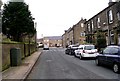
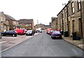
4
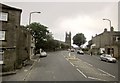
West End, Queensbury
The A647 climbs towards Holy Trinity Church http://www.britishlistedbuildings.co.uk/en-337419-church-of-the-holy-trinity- .
Image: © Derek Harper
Taken: 3 Jul 2014
0.02 miles
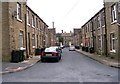
9
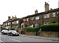
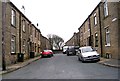
Houses in Chapel Street opposite Church
Image: © Betty Longbottom
Taken: 21 Aug 2007
0.03 miles