IMAGES TAKEN NEAR TO
Prospect View, BRADFORD, BD13 2DW
Introduction
This page details the photographs taken nearby to Prospect View, BD13 2DW by members of the Geograph project.
The Geograph project started in 2005 with the aim of publishing, organising and preserving representative images for every square kilometre of Great Britain, Ireland and the Isle of Man.

There are currently over 7.5m images from over14,400 individuals and you can help contribute to the project by visiting https://www.geograph.org.uk
Image Map (Loading...)


Getting Data...Please wait
Leaflet Map data © OpenStreetMap
Images are licensed for reuse under creativecommons.org/licenses/by-sa/2.0
Notes
- Clicking on the map will re-center to the selected point.
- The higher the marker number, the further away the image location is from the centre of the postcode.
Image Listing (102 Images Found)
Images are licensed for reuse under creativecommons.org/licenses/by-sa/2.0
Image
Details
Distance
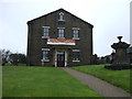
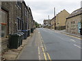
3
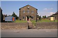
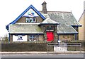
Union Croft Independent Chapel
Looking W from Halifax Road.
Image: © Mark Anderson
Taken: 18 Aug 2005
0.03 miles
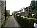
5
Roper Lane at Ambler Thorn
Looking north-westward.
Image: © Peter Wood
Taken: 28 Aug 2018
0.04 miles
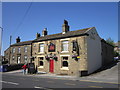
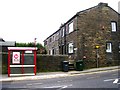
9
Shibden Head Day Nursery - Halifax Road
Image: © Betty Longbottom
Taken: 27 Dec 2008
0.04 miles
10
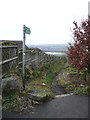
Queensbury Bridleway 35 at Roper Lane
Image: © Humphrey Bolton
Taken: 6 Feb 2017
0.05 miles