IMAGES TAKEN NEAR TO
Sunny View Terrace, BRADFORD, BD13 2DA
Introduction
This page details the photographs taken nearby to Sunny View Terrace, BD13 2DA by members of the Geograph project.
The Geograph project started in 2005 with the aim of publishing, organising and preserving representative images for every square kilometre of Great Britain, Ireland and the Isle of Man.

There are currently over 7.5m images from over14,400 individuals and you can help contribute to the project by visiting https://www.geograph.org.uk
Image Map (Loading...)


Getting Data...Please wait
Leaflet Map data © OpenStreetMap
Images are licensed for reuse under creativecommons.org/licenses/by-sa/2.0
Notes
- Clicking on the map will re-center to the selected point.
- The higher the marker number, the further away the image location is from the centre of the postcode.
Image Listing (101 Images Found)
Images are licensed for reuse under creativecommons.org/licenses/by-sa/2.0
Image
Details
Distance
4
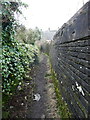
Queensbury FP30
This narrow enclosed path was between fields in 1850.
Image: © Humphrey Bolton
Taken: 6 Feb 2017
0.04 miles
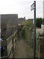
5
Queensbury FP35 at Roper Lane
This is opposite Beggarington Lane, which now has a more genteel name: Ladysmith Road.
Image: © Humphrey Bolton
Taken: 6 Feb 2017
0.04 miles

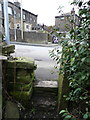
9
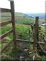
Stile on Queensbury FP35
This path drops down from Roper Lane to the site of the farm at Bracken Hill.
Image: © Humphrey Bolton
Taken: 6 Feb 2017
0.06 miles