IMAGES TAKEN NEAR TO
Brighouse Road, BRADFORD, BD13 1QF
Introduction
This page details the photographs taken nearby to Brighouse Road, BD13 1QF by members of the Geograph project.
The Geograph project started in 2005 with the aim of publishing, organising and preserving representative images for every square kilometre of Great Britain, Ireland and the Isle of Man.

There are currently over 7.5m images from over14,400 individuals and you can help contribute to the project by visiting https://www.geograph.org.uk
Image Map (Loading...)


Getting Data...Please wait
Leaflet Map data © OpenStreetMap
Images are licensed for reuse under creativecommons.org/licenses/by-sa/2.0
Notes
- Clicking on the map will re-center to the selected point.
- The higher the marker number, the further away the image location is from the centre of the postcode.
Image Listing (52 Images Found)
Images are licensed for reuse under creativecommons.org/licenses/by-sa/2.0
Image
Details
Distance
1
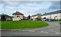
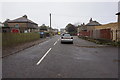
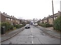
Hillcrest Road, Queensbury
This is the eastern end of a loop off Hillcrest Road, without a name of its own.
Image: © Humphrey Bolton
Taken: 14 Oct 2021
0.04 miles
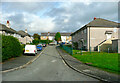
2
Harrowins Farm Drive, Brighouse Road, Queensbury
Image: © Ian S
Taken: 15 Oct 2016
0.05 miles
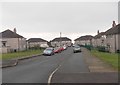
4
Hillcrest Road, Queensbury
This is the north-western end of a loop off Hillcrest Road, without a name of its own.
Image: © Humphrey Bolton
Taken: 14 Oct 2021
0.06 miles
5
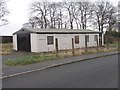
Church of the Nazarene - Hillcrest Road
Image: © Betty Longbottom
Taken: 5 Jan 2013
0.07 miles
6
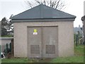
Electricity Substation No 500 - Hillcrest Avenue
Image: © Betty Longbottom
Taken: 5 Jan 2013
0.07 miles
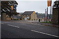
10
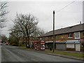
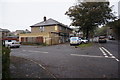
Bus stop and shops on Brighouse Road, Queensbury
Image: © Steve Fareham
Taken: 28 Feb 2010
0.10 miles