IMAGES TAKEN NEAR TO
Blackshaw Beck Lane, BRADFORD, BD13 1LU
Introduction
This page details the photographs taken nearby to Blackshaw Beck Lane, BD13 1LU by members of the Geograph project.
The Geograph project started in 2005 with the aim of publishing, organising and preserving representative images for every square kilometre of Great Britain, Ireland and the Isle of Man.

There are currently over 7.5m images from over14,400 individuals and you can help contribute to the project by visiting https://www.geograph.org.uk
Image Map (Loading...)


Getting Data...Please wait
Leaflet Map data © OpenStreetMap
Images are licensed for reuse under creativecommons.org/licenses/by-sa/2.0
Notes
- Clicking on the map will re-center to the selected point.
- The higher the marker number, the further away the image location is from the centre of the postcode.
Image Listing (36 Images Found)
Images are licensed for reuse under creativecommons.org/licenses/by-sa/2.0
Image
Details
Distance
1
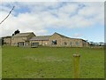
North Whins Farm
An archive article on the Telegraph & Argus website says that the original farmhouse was destroyed by a lightning strike in 1998, so this is a rebuild.
Image: © Stephen Craven
Taken: 12 Mar 2022
0.02 miles
2
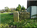
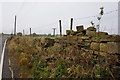
Blocked footpath at North Whins Farm
The wall across the path looks recent. There is a footpath gate further on, but then I think a house has been built over the path.
Image: © Humphrey Bolton
Taken: 14 Oct 2021
0.04 miles
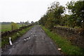
5
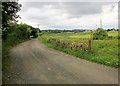
Blackshaw Beck Lane
A route with public access following an administrative boundary from High Cross towards Old Dolphin.
Image: © Derek Harper
Taken: 3 Jul 2014
0.06 miles
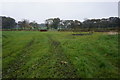
7

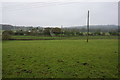
View from Blackshaw Beck Lane, Shelf
I was surprised to see the new houses to the left of the pylon. They are on the site of a farm and bacon factory, so I suppose it was a 'brown-field' site although presumably in the green belt. To the right there is an electricity sub-station supplying electricity by overhead wires.
Image: © Humphrey Bolton
Taken: 19 Sep 2020
0.07 miles
8
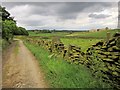
Blackshaw Beck Lane
Further along the track shown in Image On the right is a new housing estate at The Pastures, by the Giles Hill Farms.
Image: © Derek Harper
Taken: 3 Jul 2014
0.10 miles
10
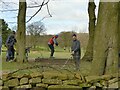
Teeing off at Queensbury Golf Club
One of these golfers was happy to pose while another was driving off the tee.
Image: © Stephen Craven
Taken: 12 Mar 2022
0.11 miles