IMAGES TAKEN NEAR TO
Whitehall Road, BRADFORD, BD12 9LP
Introduction
This page details the photographs taken nearby to Whitehall Road, BD12 9LP by members of the Geograph project.
The Geograph project started in 2005 with the aim of publishing, organising and preserving representative images for every square kilometre of Great Britain, Ireland and the Isle of Man.

There are currently over 7.5m images from over14,400 individuals and you can help contribute to the project by visiting https://www.geograph.org.uk
Image Map (Loading...)


Getting Data...Please wait
Leaflet Map data © OpenStreetMap
Images are licensed for reuse under creativecommons.org/licenses/by-sa/2.0
Notes
- Clicking on the map will re-center to the selected point.
- The higher the marker number, the further away the image location is from the centre of the postcode.
Image Listing (75 Images Found)
Images are licensed for reuse under creativecommons.org/licenses/by-sa/2.0
Image
Details
Distance

2
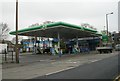
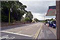
BP Filling Station - Whitehall Road
Image: © Betty Longbottom
Taken: 22 Apr 2008
0.05 miles
3
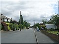
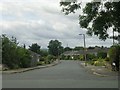
Sellerdale Rise - Sellerdale Avenue
Image: © Betty Longbottom
Taken: 8 Jul 2009
0.09 miles

5
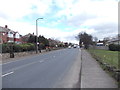
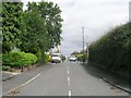
Whitehall Road - viewed from Corrance Road
Image: © Betty Longbottom
Taken: 19 Mar 2012
0.09 miles
8

Westfield United Reformed Church, Wyke
Westfield United Reformed Church SE157266 was built in 1824 as the Westfield Independent Chapel. It has a pediment gabled front of sandstone "brick" (ie brick-size stones) with a stone slate roof. There are two doorways with cornice hoods on console brackets. The corniced plaque below the central first floor window has an inscription with the date in Roman numerals. The next building is the Sunday School, then a house in similar style that was presumably connected with the church.
Image: © Humphrey Bolton
Taken: 22 Aug 2005
0.10 miles