IMAGES TAKEN NEAR TO
Wilson Road, BRADFORD, BD12 9HA
Introduction
This page details the photographs taken nearby to Wilson Road, BD12 9HA by members of the Geograph project.
The Geograph project started in 2005 with the aim of publishing, organising and preserving representative images for every square kilometre of Great Britain, Ireland and the Isle of Man.

There are currently over 7.5m images from over14,400 individuals and you can help contribute to the project by visiting https://www.geograph.org.uk
Image Map (Loading...)


Getting Data...Please wait
Leaflet Map data © OpenStreetMap
Images are licensed for reuse under creativecommons.org/licenses/by-sa/2.0
Notes
- Clicking on the map will re-center to the selected point.
- The higher the marker number, the further away the image location is from the centre of the postcode.
Image Listing (109 Images Found)
Images are licensed for reuse under creativecommons.org/licenses/by-sa/2.0
Image
Details
Distance
2
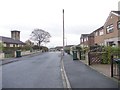
Elizabeth Avenue - looking towards Rawson Street
Image: © Betty Longbottom
Taken: 22 Nov 2011
0.05 miles
3
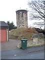
Air Shaft - Wyke Tunnel - viewed from Elizabeth Avenue
Image: © Betty Longbottom
Taken: 22 Nov 2011
0.06 miles
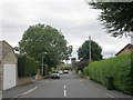
5
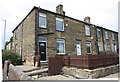
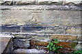
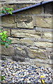
Houses of Wilson Road
There is an OS benchmark Image on the side of the left hand house just beyond the bucket hanging from the wall
Image: © Luke Shaw
Taken: 23 Aug 2018
0.06 miles
6
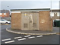
Electricity Substation No 1177 - Mayfield Rise
Image: © Betty Longbottom
Taken: 22 Nov 2011
0.07 miles
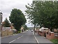
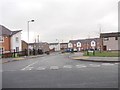
8
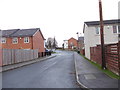
Clayhill Drive - looking towards Wilson Road
Image: © Betty Longbottom
Taken: 22 Nov 2011
0.07 miles
9
Elizabeth Avenue - Huddersfield Road
Image: © Betty Longbottom
Taken: 8 Jul 2009
0.09 miles