IMAGES TAKEN NEAR TO
Knowle Lane, BRADFORD, BD12 9BG
Introduction
This page details the photographs taken nearby to Knowle Lane, BD12 9BG by members of the Geograph project.
The Geograph project started in 2005 with the aim of publishing, organising and preserving representative images for every square kilometre of Great Britain, Ireland and the Isle of Man.

There are currently over 7.5m images from over14,400 individuals and you can help contribute to the project by visiting https://www.geograph.org.uk
Image Map
Images are licensed for reuse under creativecommons.org/licenses/by-sa/2.0
Notes
- Clicking on the map will re-center to the selected point.
- The higher the marker number, the further away the image location is from the centre of the postcode.
Image Listing (66 Images Found)
Images are licensed for reuse under creativecommons.org/licenses/by-sa/2.0
Image
Details
Distance
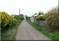
1
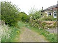
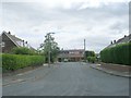
Knowl, Wyke
This is the name on the 1850 map; the present house is perhaps a rebuilding of the original one. Here Knowle Lane becomes Cow Close Lane, which has the character of a bridleway.
Image: © Humphrey Bolton
Taken: 23 Apr 2009
0.05 miles
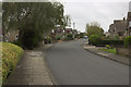
2
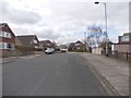
Silver Birch Drive - viewed from Silver Birch Avenue
Image: © Betty Longbottom
Taken: 19 Mar 2012
0.05 miles
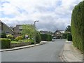
3
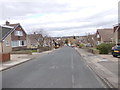
Silver Birch Avenue - looking towards Wyke Lane
Image: © Betty Longbottom
Taken: 19 Mar 2012
0.05 miles
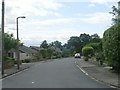
4
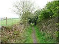
Cow Close Lane, Wyke
Not on the map as a public footpath or bridleway, so presumably a public road. The Wyke chemical works is on the left.
Image: © Humphrey Bolton
Taken: 23 Apr 2009
0.08 miles

8
Silver Birch Grove - Silver Birch Drive
Image: © Betty Longbottom
Taken: 8 Jul 2009
0.12 miles
10
Knowle Lane, Wyke
This led to Knowl (the 'e' on the end was added after 1850), and then the lane continued with the name Cow Close Lane to Cow Close, all quite logical.
Image: © Humphrey Bolton
Taken: 23 Apr 2009
0.12 miles