IMAGES TAKEN NEAR TO
Wyke Lane, BRADFORD, BD12 9BA
Introduction
This page details the photographs taken nearby to Wyke Lane, BD12 9BA by members of the Geograph project.
The Geograph project started in 2005 with the aim of publishing, organising and preserving representative images for every square kilometre of Great Britain, Ireland and the Isle of Man.

There are currently over 7.5m images from over14,400 individuals and you can help contribute to the project by visiting https://www.geograph.org.uk
Image Map
Images are licensed for reuse under creativecommons.org/licenses/by-sa/2.0
Notes
- Clicking on the map will re-center to the selected point.
- The higher the marker number, the further away the image location is from the centre of the postcode.
Image Listing (129 Images Found)
Images are licensed for reuse under creativecommons.org/licenses/by-sa/2.0
Image
Details
Distance
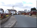
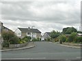
5
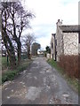
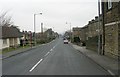
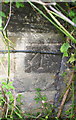
#188 Westfield Lane at Wyke Lane junction
There is an OS benchmark Image on the right hand corner, left hand face, of the house, behind bushes
Image: © Luke Shaw
Taken: 23 Aug 2018
0.04 miles
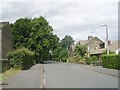
7
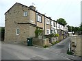
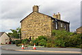
New Row, Wyke
With a narrow access road off Knowle Lane.
Image: © Humphrey Bolton
Taken: 23 Apr 2009
0.05 miles