IMAGES TAKEN NEAR TO
Huddersfield Road, BRADFORD, BD12 8NA
Introduction
This page details the photographs taken nearby to Huddersfield Road, BD12 8NA by members of the Geograph project.
The Geograph project started in 2005 with the aim of publishing, organising and preserving representative images for every square kilometre of Great Britain, Ireland and the Isle of Man.

There are currently over 7.5m images from over14,400 individuals and you can help contribute to the project by visiting https://www.geograph.org.uk
Image Map
Images are licensed for reuse under creativecommons.org/licenses/by-sa/2.0
Notes
- Clicking on the map will re-center to the selected point.
- The higher the marker number, the further away the image location is from the centre of the postcode.
Image Listing (176 Images Found)
Images are licensed for reuse under creativecommons.org/licenses/by-sa/2.0
Image
Details
Distance
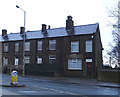
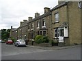
2
Terrace backs, Upper Wyke
A view down the back alley of two rows of sandstone terraces on Mayfield Place and the B6379 Huddersfield Road.
Image: © Bobby Clegg
Taken: 14 Sep 2014
0.02 miles
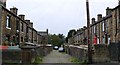
6
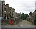
Back Mayfield Place - Mayfield Avenue
Image: © Betty Longbottom
Taken: 8 Jul 2009
0.03 miles
8
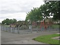
Playground - Upper Wyke Recreation Ground
Image: © Betty Longbottom
Taken: 8 Jul 2009
0.04 miles
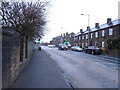
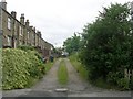
9
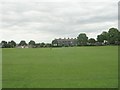
Upper Wyke Recreation Ground - viewed from Towngate
Image: © Betty Longbottom
Taken: 8 Jul 2009
0.04 miles
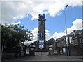
10
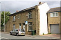
#2 Town Gate and #569 Huddersfield Road
There is an OS benchmark Image on the front of the right hand house under its For Sale sign
Image: © Luke Shaw
Taken: 23 Aug 2018
0.04 miles