IMAGES TAKEN NEAR TO
Whitehall Road, BRADFORD, BD12 8LL
Introduction
This page details the photographs taken nearby to Whitehall Road, BD12 8LL by members of the Geograph project.
The Geograph project started in 2005 with the aim of publishing, organising and preserving representative images for every square kilometre of Great Britain, Ireland and the Isle of Man.

There are currently over 7.5m images from over14,400 individuals and you can help contribute to the project by visiting https://www.geograph.org.uk
Image Map (Loading...)


Getting Data...Please wait
Leaflet Map data © OpenStreetMap
Images are licensed for reuse under creativecommons.org/licenses/by-sa/2.0
Notes
- Clicking on the map will re-center to the selected point.
- The higher the marker number, the further away the image location is from the centre of the postcode.
Image Listing (106 Images Found)
Images are licensed for reuse under creativecommons.org/licenses/by-sa/2.0
Image
Details
Distance
4
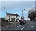
The Wyke Lion, Whitehall Road (A58)
The Wyke Lion is situated at Hellfire Crossroads, the junction of Whitehall Road (A58) and Bradford and Huddersfield Roads (A641).
Image: © habiloid
Taken: 14 Mar 2020
0.01 miles
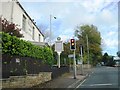
5
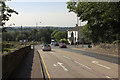
Traffic Lights, Wyke
Looking along the A58 towards the Wyke Lion Public House
Image: © Mark Anderson
Taken: 13 Sep 2016
0.02 miles
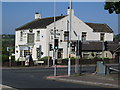
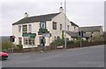
6
Wyke Lion public house from Huddersfield Road
Image: © Steve Fareham
Taken: 20 Apr 2010
0.02 miles
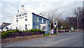
7
Wyke Lion - Huddersfield Road, Wyke
Image: © Betty Longbottom
Taken: 19 Apr 2008
0.03 miles
8
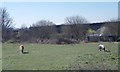
Ponies grazing - off Whitehall Road
Image: © Betty Longbottom
Taken: 26 Mar 2012
0.03 miles
9
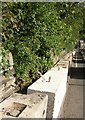
Concrete blocks, Huddersfield Road, Wyke
These are holding back a dry-stone retaining wall that is in a state of collapse.
Image: © Humphrey Bolton
Taken: 6 Aug 2007
0.04 miles
10
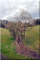
Stream, Lower Wyke
This small stream is seen from Huddersfield Road (A641).
Image: © habiloid
Taken: 14 Mar 2020
0.05 miles