IMAGES TAKEN NEAR TO
Huddersfield Road, BRADFORD, BD12 8AD
Introduction
This page details the photographs taken nearby to Huddersfield Road, BD12 8AD by members of the Geograph project.
The Geograph project started in 2005 with the aim of publishing, organising and preserving representative images for every square kilometre of Great Britain, Ireland and the Isle of Man.

There are currently over 7.5m images from over14,400 individuals and you can help contribute to the project by visiting https://www.geograph.org.uk
Image Map (151 Images)


Getting Data...Please wait
Leaflet Map data © OpenStreetMap
Images are licensed for reuse under creativecommons.org/licenses/by-sa/2.0
Notes
- Clicking on the map will re-center to the selected point.
- The higher the marker number, the further away the image location is from the centre of the postcode.
Image Listing (151 Images Found)
Images are licensed for reuse under creativecommons.org/licenses/by-sa/2.0
Image
Details
Distance
5
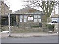
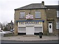
Royds Community Association - Huddersfield Road
Image: © Betty Longbottom
Taken: 23 Feb 2010
0.03 miles
6
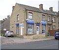
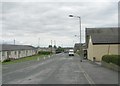
Mayfield Avenue - Huddersfield Road
Image: © Betty Longbottom
Taken: 8 Jul 2009
0.03 miles
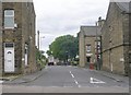
7
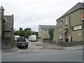
#526 Huddersfield Road at Wrose Place junction
There is an OS benchmark Image on the near corner, right hand face, of the deli bar, above an access ramp
Image: © Luke Shaw
Taken: 23 Aug 2018
0.03 miles
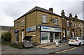
9
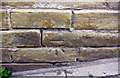
Benchmark on #526 Huddersfield Road, RendezVous Deli Bar
Image: © Luke Shaw
Taken: 23 Aug 2018
0.03 miles