IMAGES TAKEN NEAR TO
Dye House Fold, BRADFORD, BD12 7BU
Introduction
This page details the photographs taken nearby to Dye House Fold, BD12 7BU by members of the Geograph project.
The Geograph project started in 2005 with the aim of publishing, organising and preserving representative images for every square kilometre of Great Britain, Ireland and the Isle of Man.

There are currently over 7.5m images from over14,400 individuals and you can help contribute to the project by visiting https://www.geograph.org.uk
Image Map
Images are licensed for reuse under creativecommons.org/licenses/by-sa/2.0
Notes
- Clicking on the map will re-center to the selected point.
- The higher the marker number, the further away the image location is from the centre of the postcode.
Image Listing (86 Images Found)
Images are licensed for reuse under creativecommons.org/licenses/by-sa/2.0
Image
Details
Distance
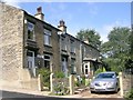
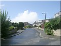
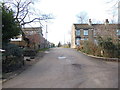
2
Snake Hill, North Bierley
This is the name of the area where the houses are beyond the field. To the left of the view there is Dyehouse Fold.
Image: © Humphrey Bolton
Taken: 16 Jul 2007
0.02 miles
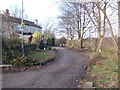
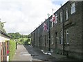
6
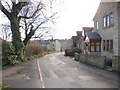
Dyehouse Road - looking towards Cleckheaton Road
Image: © Betty Longbottom
Taken: 22 Dec 2011
0.04 miles