IMAGES TAKEN NEAR TO
Rosehill Crescent, BRADFORD, BD12 0UZ
Introduction
This page details the photographs taken nearby to Rosehill Crescent, BD12 0UZ by members of the Geograph project.
The Geograph project started in 2005 with the aim of publishing, organising and preserving representative images for every square kilometre of Great Britain, Ireland and the Isle of Man.

There are currently over 7.5m images from over14,400 individuals and you can help contribute to the project by visiting https://www.geograph.org.uk
Image Map (Loading...)


Getting Data...Please wait
Leaflet Map data © OpenStreetMap
Images are licensed for reuse under creativecommons.org/licenses/by-sa/2.0
Notes
- Clicking on the map will re-center to the selected point.
- The higher the marker number, the further away the image location is from the centre of the postcode.
Image Listing (108 Images Found)
Images are licensed for reuse under creativecommons.org/licenses/by-sa/2.0
Image
Details
Distance
1
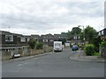
Wavertree Park Gardens - Rosehill Crescent
Image: © Betty Longbottom
Taken: 8 Jul 2009
0.02 miles
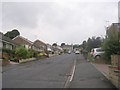
2
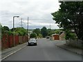
Rosehill Crescent - Huddersfield Road
Image: © Betty Longbottom
Taken: 8 Jul 2009
0.03 miles
5
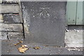
Benchmark on left hand gatepost at entrance to #380 Huddersfield Road
Image: © Luke Shaw
Taken: 23 Aug 2018
0.06 miles
6
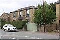
#380 Huddersfield Road, The Water House
There is an OS benchmark Image on the gatepost on the left hand side of the wooden gates
Image: © Luke Shaw
Taken: 23 Aug 2018
0.06 miles
8
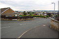
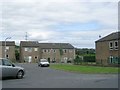
Markfield Drive approaching Markfield Close junction
Image: © Roger Templeman
Taken: 23 Aug 2018
0.07 miles
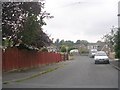
9
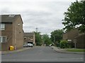
Markfield Drive - looking towards Huddersfield Road
Image: © Betty Longbottom
Taken: 26 Aug 2011
0.07 miles
10
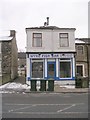
Wyke Fish Bar - Huddersfield Road
Image: © Betty Longbottom
Taken: 23 Feb 2010
0.07 miles