IMAGES TAKEN NEAR TO
Abb Scott Lane, BRADFORD, BD12 0TR
Introduction
This page details the photographs taken nearby to Abb Scott Lane, BD12 0TR by members of the Geograph project.
The Geograph project started in 2005 with the aim of publishing, organising and preserving representative images for every square kilometre of Great Britain, Ireland and the Isle of Man.

There are currently over 7.5m images from over14,400 individuals and you can help contribute to the project by visiting https://www.geograph.org.uk
Image Map (Loading...)


Getting Data...Please wait
Leaflet Map data © OpenStreetMap
Images are licensed for reuse under creativecommons.org/licenses/by-sa/2.0
Notes
- Clicking on the map will re-center to the selected point.
- The higher the marker number, the further away the image location is from the centre of the postcode.
Image Listing (109 Images Found)
Images are licensed for reuse under creativecommons.org/licenses/by-sa/2.0
Image
Details
Distance
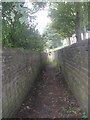
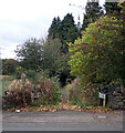
3
Ginnel between Abb Scott Lane and Common Road, Bradford
Image: © habiloid
Taken: 27 Oct 2021
0.03 miles
5
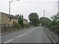
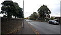
Abb Scott Lane - viewed from Common Road
Image: © Betty Longbottom
Taken: 26 Aug 2011
0.04 miles
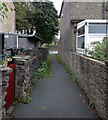
6
School Fold seen from Abb Scott Lane, Bradford
Image: © habiloid
Taken: 27 Oct 2021
0.04 miles
8
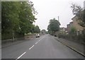
Common Road - viewed from AbbScott Lane
Image: © Betty Longbottom
Taken: 26 Aug 2011
0.05 miles
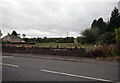
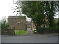
9
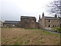
Moorside Farm, off Abb Scott Lane
Listed grade 2, this farmhouse apparently dates in part to 1700 although most of it is early 19th century (the older part is to the rear). It certainly appears on OS maps as early as 1852, pre-dating Abb Scott Lane itself.
Image: © Stephen Craven
Taken: 10 Feb 2018
0.05 miles
10
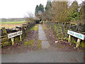
School Fold, off Abb Scott Lane
School Fold is a group of cottages in the trees at the end of this path; aerial imagery suggests they are now derelict. But they appear on OS maps as early as 1852, pre-dating Abb Scott Lane itself.
Image: © Stephen Craven
Taken: 10 Feb 2018
0.06 miles