IMAGES TAKEN NEAR TO
Hird Road, BRADFORD, BD12 0TA
Introduction
This page details the photographs taken nearby to Hird Road, BD12 0TA by members of the Geograph project.
The Geograph project started in 2005 with the aim of publishing, organising and preserving representative images for every square kilometre of Great Britain, Ireland and the Isle of Man.

There are currently over 7.5m images from over14,400 individuals and you can help contribute to the project by visiting https://www.geograph.org.uk
Image Map (Loading...)


Getting Data...Please wait
Leaflet Map data © OpenStreetMap
Images are licensed for reuse under creativecommons.org/licenses/by-sa/2.0
Notes
- Clicking on the map will re-center to the selected point.
- The higher the marker number, the further away the image location is from the centre of the postcode.
Image Listing (78 Images Found)
Images are licensed for reuse under creativecommons.org/licenses/by-sa/2.0
Image
Details
Distance

5
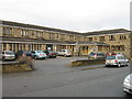
Guide Post Hotel, Low Moor
A Best Western Hotel
Image: © Alex McGregor
Taken: 6 Jan 2011
0.03 miles
6
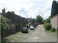
Besha Street - off Low Moor Street
Image: © Betty Longbottom
Taken: 14 Jun 2009
0.04 miles
7
Aldersgate Methodist Church, Common Road, Low Moor, North Bierley
Opposite the war memorial
Image: © Humphrey Bolton
Taken: 16 Jul 2007
0.06 miles