IMAGES TAKEN NEAR TO
Tordoff Road, BRADFORD, BD12 0HU
Introduction
This page details the photographs taken nearby to Tordoff Road, BD12 0HU by members of the Geograph project.
The Geograph project started in 2005 with the aim of publishing, organising and preserving representative images for every square kilometre of Great Britain, Ireland and the Isle of Man.

There are currently over 7.5m images from over14,400 individuals and you can help contribute to the project by visiting https://www.geograph.org.uk
Image Map
Images are licensed for reuse under creativecommons.org/licenses/by-sa/2.0
Notes
- Clicking on the map will re-center to the selected point.
- The higher the marker number, the further away the image location is from the centre of the postcode.
Image Listing (92 Images Found)
Images are licensed for reuse under creativecommons.org/licenses/by-sa/2.0
Image
Details
Distance
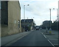
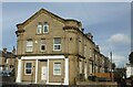
3
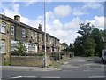
Cleckheaton Industrial Society Ltd - Cleckheaton Road
Built 1883.
Image: © Betty Longbottom
Taken: 15 Dec 2007
0.02 miles
8
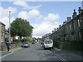
First Street - viewed from Main Street
Image: © Betty Longbottom
Taken: 28 Aug 2009
0.05 miles
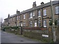
9
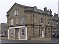
Former Cleckheaton Industrial Society Ltd, Cleckheaton Road, Bradford
Image: © Stephen Armstrong
Taken: 26 Oct 2021
0.05 miles
10
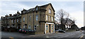
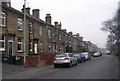
Old Co-Op building, Cleckheaton Road, Low Moor
This building has inscriptions on it reading "Cleckheaton Industrial Co-operative Society, Limited. A.D. 1883". It is now a residential building.
Image: © habiloid
Taken: 28 Dec 2019
0.05 miles