IMAGES TAKEN NEAR TO
Far Crook, BRADFORD, BD10 8WF
Introduction
This page details the photographs taken nearby to Far Crook, BD10 8WF by members of the Geograph project.
The Geograph project started in 2005 with the aim of publishing, organising and preserving representative images for every square kilometre of Great Britain, Ireland and the Isle of Man.

There are currently over 7.5m images from over14,400 individuals and you can help contribute to the project by visiting https://www.geograph.org.uk
Image Map
Images are licensed for reuse under creativecommons.org/licenses/by-sa/2.0
Notes
- Clicking on the map will re-center to the selected point.
- The higher the marker number, the further away the image location is from the centre of the postcode.
Image Listing (68 Images Found)
Images are licensed for reuse under creativecommons.org/licenses/by-sa/2.0
Image
Details
Distance
1
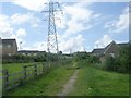
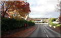
Cote Farm Lane - Leeds Road, Windhill
Image: © Betty Longbottom
Taken: 18 Nov 2008
0.03 miles
3
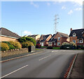
Cote Farm Lane, Thackley, Bradford
A close-up of the post box can be seen in Image
Image: © habiloid
Taken: 25 Oct 2021
0.04 miles
4
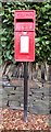
Post box, Cote Farm Lane, Thackley, Bradford
This post box can be seen in context in Image
Image: © habiloid
Taken: 25 Oct 2021
0.04 miles
7
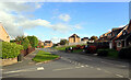
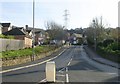
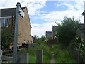
The junction of Cote Farm Lane and Stead Hill Way, Thackley
Image: © habiloid
Taken: 25 Oct 2021
0.05 miles
8
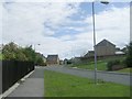
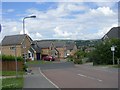
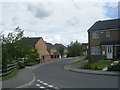
Stead Hill Way - viewed from Cote Farm Lane
Image: © Betty Longbottom
Taken: 11 Jul 2011
0.05 miles