IMAGES TAKEN NEAR TO
Woodsley Road, BRADFORD, BD10 8QL
Introduction
This page details the photographs taken nearby to Woodsley Road, BD10 8QL by members of the Geograph project.
The Geograph project started in 2005 with the aim of publishing, organising and preserving representative images for every square kilometre of Great Britain, Ireland and the Isle of Man.

There are currently over 7.5m images from over14,400 individuals and you can help contribute to the project by visiting https://www.geograph.org.uk
Image Map
Images are licensed for reuse under creativecommons.org/licenses/by-sa/2.0
Notes
- Clicking on the map will re-center to the selected point.
- The higher the marker number, the further away the image location is from the centre of the postcode.
Image Listing (109 Images Found)
Images are licensed for reuse under creativecommons.org/licenses/by-sa/2.0
Image
Details
Distance
1
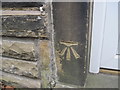
Ordnance Survey Cut Mark
The mark can be found on 1 Woodsley Road.
For more details see : http://www.bench-marks.org.uk/bm41390
Image: © Peter Wood
Taken: 14 Feb 2012
0.01 miles
5
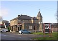
The Balloon & Basket - Highfield Road
Image: © Betty Longbottom
Taken: 25 Nov 2008
0.05 miles
6
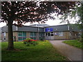
Blakehill Primary School - Highfield Road
Image: © Betty Longbottom
Taken: 28 Apr 2011
0.07 miles
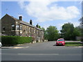
7
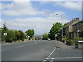
Highfield Road - viewed from Doctor Hill
Image: © Betty Longbottom
Taken: 28 Apr 2011
0.07 miles
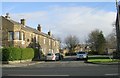
8
Highfield Road - viewed from Doctor Hill
Image: © Betty Longbottom
Taken: 28 Apr 2011
0.07 miles
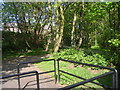
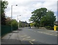
9
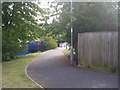
Footpath - Javelin Close to Bradford Road
Image: © Betty Longbottom
Taken: 28 Apr 2011
0.08 miles
10
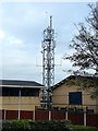
The police station radio mast, Idle
Image: © Humphrey Bolton
Taken: 21 Oct 2011
0.08 miles