IMAGES TAKEN NEAR TO
High Street, BRADFORD, BD10 8QA
Introduction
This page details the photographs taken nearby to High Street, BD10 8QA by members of the Geograph project.
The Geograph project started in 2005 with the aim of publishing, organising and preserving representative images for every square kilometre of Great Britain, Ireland and the Isle of Man.

There are currently over 7.5m images from over14,400 individuals and you can help contribute to the project by visiting https://www.geograph.org.uk
Image Map
Images are licensed for reuse under creativecommons.org/licenses/by-sa/2.0
Notes
- Clicking on the map will re-center to the selected point.
- The higher the marker number, the further away the image location is from the centre of the postcode.
Image Listing (157 Images Found)
Images are licensed for reuse under creativecommons.org/licenses/by-sa/2.0
Image
Details
Distance
1
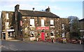
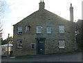
The White Bear, Idle
Grade II listed (list entry 1133096). Watson gives us the facts that it dates from some time before 1822, at which time it was owned by the Stansfields of Esholt Hall, one of whose number also acted as landlord in the mid 19th century. He adds that in his own time (late 19th/early 20th century?) it was kept by Lewis Cannon, his wife and their "bevy of beautiful daughters".
Image: © Stephen Craven
Taken: 4 Apr 2021
0.00 miles
2
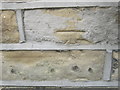
Ordnance Survey Cut Mark
This mark can be found on the wall of 2 Greenfield Lane.
For more detail see : http://www.bench-marks.org.uk/bm43836
Image: © Peter Wood
Taken: 8 Jul 2012
0.01 miles
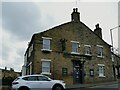
4
Idle Medical Centre - Highfield Road
Image: © Betty Longbottom
Taken: 13 Nov 2007
0.02 miles
5
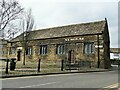
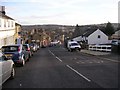
The Old Chapel, Idle
This building standing in the triangular junction of Westfield Lane and Town Lane was built in 1630 as a chapel of ease to Calverley parish, but not consecrated until 1692 and prior to this date used by non-conformist congregations as well, an unusual case (from EH listing). From 1830 it was superseded for regular worship by Holy Trinity parish church nearby and became the Sunday School. The font was taken to the new church Image As of 1968 it was leased to Idle Parish Council for use by the Scouts and Guides; when the listing was written in 1983 it was a YMCA community centre, but is currently used by the Yorkshire School of Performing Arts as a drama school and has been since at least 2007 Image Listed grade II* (list entry 1133673).
Image: © Stephen Craven
Taken: 4 Apr 2021
0.02 miles
8
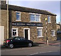
Idle National Spiritualist Church - Highfield Road
Image: © Betty Longbottom
Taken: 13 Nov 2007
0.02 miles
9
Ordnance Survey Cut Mark
This mark can be found on the wall of the New Inn.
For more detail see : http://www.bench-marks.org.uk/bm43837
Image: © Peter Wood
Taken: 8 Jul 2012
0.03 miles