IMAGES TAKEN NEAR TO
Booth Royd, BRADFORD, BD10 8LN
Introduction
This page details the photographs taken nearby to Booth Royd, BD10 8LN by members of the Geograph project.
The Geograph project started in 2005 with the aim of publishing, organising and preserving representative images for every square kilometre of Great Britain, Ireland and the Isle of Man.

There are currently over 7.5m images from over14,400 individuals and you can help contribute to the project by visiting https://www.geograph.org.uk
Image Map
Images are licensed for reuse under creativecommons.org/licenses/by-sa/2.0
Notes
- Clicking on the map will re-center to the selected point.
- The higher the marker number, the further away the image location is from the centre of the postcode.
Image Listing (150 Images Found)
Images are licensed for reuse under creativecommons.org/licenses/by-sa/2.0
Image
Details
Distance
1
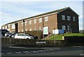
Thackley Grange Community Health Centre - Booth Royd Avenue
Image: © Betty Longbottom
Taken: 13 Nov 2007
0.03 miles
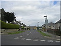
8
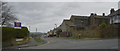
Harehill Road
Town Lane crosses the foreground.
Image: © habiloid
Taken: 22 Feb 2020
0.08 miles
9
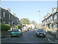
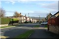
Garden Terrace - Sherborne Road, Idle
Image: © Betty Longbottom
Taken: 25 Nov 2008
0.08 miles