IMAGES TAKEN NEAR TO
Leeds Road, BRADFORD, BD10 8JS
Introduction
This page details the photographs taken nearby to Leeds Road, BD10 8JS by members of the Geograph project.
The Geograph project started in 2005 with the aim of publishing, organising and preserving representative images for every square kilometre of Great Britain, Ireland and the Isle of Man.

There are currently over 7.5m images from over14,400 individuals and you can help contribute to the project by visiting https://www.geograph.org.uk
Image Map
Images are licensed for reuse under creativecommons.org/licenses/by-sa/2.0
Notes
- Clicking on the map will re-center to the selected point.
- The higher the marker number, the further away the image location is from the centre of the postcode.
Image Listing (60 Images Found)
Images are licensed for reuse under creativecommons.org/licenses/by-sa/2.0
Image
Details
Distance
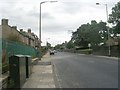
1
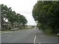
Leeds Road - viewed from Cyprus Drive
Image: © Betty Longbottom
Taken: 24 Aug 2011
0.04 miles
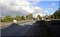
3
Cyprus Drive - Leeds Road, Thackley
Image: © Betty Longbottom
Taken: 18 Nov 2008
0.05 miles
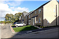
4
Little Cote Farm Close - Leeds Road
Image: © Betty Longbottom
Taken: 24 Aug 2011
0.06 miles
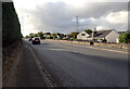
5
Leeds Road - viewed from Cyprus Drive
Image: © Betty Longbottom
Taken: 24 Aug 2011
0.06 miles
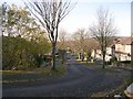
6
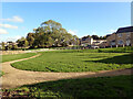
New housing seen from Leeds Road (A657), Thackley, Bradford
Houses on Little Cote View, Crooked Road and Brackendale Way are in the background.
Image: © habiloid
Taken: 25 Oct 2021
0.06 miles
9
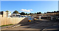
Housing development, Crooked Lane, Thackley, Bradford
Image: © habiloid
Taken: 25 Oct 2021
0.08 miles
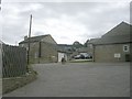
10
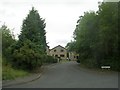
Bantree Court - off Ballantyne Road
Image: © Betty Longbottom
Taken: 24 Aug 2011
0.09 miles