IMAGES TAKEN NEAR TO
Leeds Road, BRADFORD, BD10 8JH
Introduction
This page details the photographs taken nearby to Leeds Road, BD10 8JH by members of the Geograph project.
The Geograph project started in 2005 with the aim of publishing, organising and preserving representative images for every square kilometre of Great Britain, Ireland and the Isle of Man.

There are currently over 7.5m images from over14,400 individuals and you can help contribute to the project by visiting https://www.geograph.org.uk
Image Map
Images are licensed for reuse under creativecommons.org/licenses/by-sa/2.0
Notes
- Clicking on the map will re-center to the selected point.
- The higher the marker number, the further away the image location is from the centre of the postcode.
Image Listing (121 Images Found)
Images are licensed for reuse under creativecommons.org/licenses/by-sa/2.0
Image
Details
Distance
1
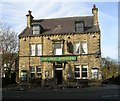
The Great Northern, Leeds Road (A657), Thackley
Image: © habiloid
Taken: 6 Apr 2020
0.02 miles
2
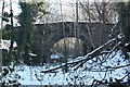
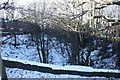
Crag Hill Road bridge, Thackley
Built in 1873, or thereabouts, the masonry arch bridge carries Crag Hill Road over the former G.N.R. Shipley to Laisterdyke railway. The railway was single track throughout its length and was closed to passenger traffic in 1931 (Trains Illustrated 1957- Rail Tour of the West Riding Part 2 by A.M.Ross) .
Image: © Richard Kay
Taken: 8 Dec 2010
0.04 miles
3
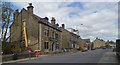
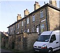
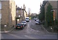
Bourne Street - Leeds Road, Thackley
Image: © Betty Longbottom
Taken: 25 Nov 2008
0.04 miles
4
Crag Hill Road Bridge, Thackley
From the road layout, it is clear that Crag Hill Road was diverted in 1873 for the construction of the bridge over the Shipley to Laisterdyke railway (now disused).
Image: © Richard Kay
Taken: 8 Dec 2010
0.04 miles
5
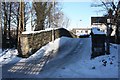
Shipley to Laisterdyke disused railway at Thackley Road
The single-line branch railway built by the G.N.R. in 1874 passed through Thackley in cutting. The railway was still in operation for goods traffic in 1957 according to 'Trains Illustrated' see http://www.lostrailwayswestyorkshire.co.uk/images/donations/Simon%20Edgerton/Trains%20illustrated%20%201957/Westyorks6.jpg. The photo shows the west headwall of the tunnel which carries Thackley Road.
Image: © Richard Kay
Taken: 8 Dec 2010
0.05 miles
6
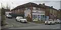
Nisa Local, Leeds Road
This convenience store is at the junction of Leeds Road (A657) and Victoria Street in Thackley.
Image: © habiloid
Taken: 22 Feb 2020
0.06 miles
7
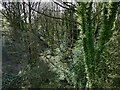
Old railway cutting west of Thackley Road
Stations on the line from Laisterdyke to Shipley closed to passengers as long ago as 1931 but it survived as a freight route until 1968. This is the result of fifty years of disuse.
Image: © Stephen Craven
Taken: 5 Apr 2021
0.06 miles
8
Regent Place - Regent Street, Thackley
Image: © Betty Longbottom
Taken: 18 Nov 2008
0.07 miles
9
The Great Northern - Leeds Road, Thackley
Image: © Betty Longbottom
Taken: 13 Nov 2007
0.07 miles
10
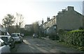
Regent Street - Leeds Road, Thackley
Image: © Betty Longbottom
Taken: 18 Nov 2008
0.07 miles