IMAGES TAKEN NEAR TO
Abbotside Close, BRADFORD, BD10 8DL
Introduction
This page details the photographs taken nearby to Abbotside Close, BD10 8DL by members of the Geograph project.
The Geograph project started in 2005 with the aim of publishing, organising and preserving representative images for every square kilometre of Great Britain, Ireland and the Isle of Man.

There are currently over 7.5m images from over14,400 individuals and you can help contribute to the project by visiting https://www.geograph.org.uk
Image Map
Images are licensed for reuse under creativecommons.org/licenses/by-sa/2.0
Notes
- Clicking on the map will re-center to the selected point.
- The higher the marker number, the further away the image location is from the centre of the postcode.
Image Listing (78 Images Found)
Images are licensed for reuse under creativecommons.org/licenses/by-sa/2.0
Image
Details
Distance
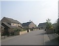
3
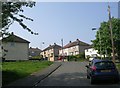
Abbotside Close - looking towards Rowantree Drive
Image: © Betty Longbottom
Taken: 22 Apr 2011
0.05 miles
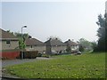
4
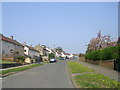
Northwood Crescent - Idlethorp Way
Image: © Betty Longbottom
Taken: 22 Apr 2011
0.09 miles
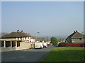
6
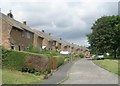
Ridge View Gardens - Northwood Crescent
Image: © Betty Longbottom
Taken: 24 Jul 2009
0.10 miles
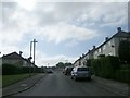
7
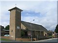
St John the Divine - Idlethorp Way
Image: © Betty Longbottom
Taken: 24 Jul 2009
0.10 miles
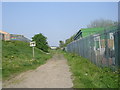
8
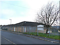
Rockwell Medical centre, Thorpe Edge
Not the most welcoming of health facilities with its security fence, but presumably a necessity in this area.
Image: © Stephen Craven
Taken: 30 Nov 2019
0.11 miles