IMAGES TAKEN NEAR TO
Dorian Close, BRADFORD, BD10 8BQ
Introduction
This page details the photographs taken nearby to Dorian Close, BD10 8BQ by members of the Geograph project.
The Geograph project started in 2005 with the aim of publishing, organising and preserving representative images for every square kilometre of Great Britain, Ireland and the Isle of Man.

There are currently over 7.5m images from over14,400 individuals and you can help contribute to the project by visiting https://www.geograph.org.uk
Image Map
Images are licensed for reuse under creativecommons.org/licenses/by-sa/2.0
Notes
- Clicking on the map will re-center to the selected point.
- The higher the marker number, the further away the image location is from the centre of the postcode.
Image Listing (123 Images Found)
Images are licensed for reuse under creativecommons.org/licenses/by-sa/2.0
Image
Details
Distance
2
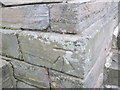
Ordnance Survey Cut Mark
This can be found on 51 Bank and easily seen from pavement without encroachment.
For more details see : http://www.bench-marks.org.uk/bm41387
Image: © Peter Wood
Taken: 14 Feb 2012
0.03 miles
5
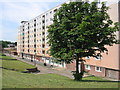
York House
York House on the Thorpe Edge Estate is an example of the high rise housing which was built in Bradford during the 1950s.
Image: © Mick Melvin
Taken: 7 Jun 2005
0.05 miles
6
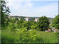
Thorpe Edge Estate
A view looking north from Crag View on Thorpe Edge Estate.
Image: © Mick Melvin
Taken: 7 Jun 2005
0.05 miles
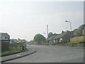
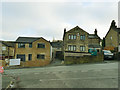
8
New Housing on Bank
Buildings erected on the trackbed of the disused railway that once ran between Shipley and Laisterdyke - as part of the Great Northern Line, which closed in 1964.
Image: © Chris Heaton
Taken: 12 Jan 2016
0.05 miles
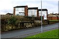
9
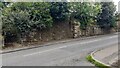
Remains of former railway bridge on south side of Bank
The bridge carried the Great Northern Railway Shipley Branch. The steps on the left lead to a footpath following the former railway's trackbed Image
Image: © Luke Shaw
Taken: 28 Aug 2024
0.05 miles
10
New house on Bank, Eccleshill
The house to the left had just been constructed as an infill development.
Image: © Stephen Craven
Taken: 30 Nov 2019
0.06 miles