IMAGES TAKEN NEAR TO
Parkstone Drive, BRADFORD, BD10 8BG
Introduction
This page details the photographs taken nearby to Parkstone Drive, BD10 8BG by members of the Geograph project.
The Geograph project started in 2005 with the aim of publishing, organising and preserving representative images for every square kilometre of Great Britain, Ireland and the Isle of Man.

There are currently over 7.5m images from over14,400 individuals and you can help contribute to the project by visiting https://www.geograph.org.uk
Image Map
Images are licensed for reuse under creativecommons.org/licenses/by-sa/2.0
Notes
- Clicking on the map will re-center to the selected point.
- The higher the marker number, the further away the image location is from the centre of the postcode.
Image Listing (116 Images Found)
Images are licensed for reuse under creativecommons.org/licenses/by-sa/2.0
Image
Details
Distance
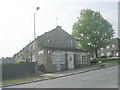
2
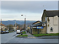
Bank Stores, Eccleshill
The name (Bank) is that of the road in the photo. The shop occupies a lean-to extension of a house.
Image: © Stephen Craven
Taken: 30 Nov 2019
0.04 miles
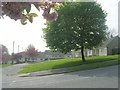
3
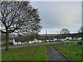
Bank Close, Eccleshill
The name (Bank) is that of the road off which this development is set.
Image: © Stephen Craven
Taken: 30 Nov 2019
0.05 miles