IMAGES TAKEN NEAR TO
Park Road, BRADFORD, BD10 0TJ
Introduction
This page details the photographs taken nearby to Park Road, BD10 0TJ by members of the Geograph project.
The Geograph project started in 2005 with the aim of publishing, organising and preserving representative images for every square kilometre of Great Britain, Ireland and the Isle of Man.

There are currently over 7.5m images from over14,400 individuals and you can help contribute to the project by visiting https://www.geograph.org.uk
Image Map
Images are licensed for reuse under creativecommons.org/licenses/by-sa/2.0
Notes
- Clicking on the map will re-center to the selected point.
- The higher the marker number, the further away the image location is from the centre of the postcode.
Image Listing (54 Images Found)
Images are licensed for reuse under creativecommons.org/licenses/by-sa/2.0
Image
Details
Distance
1
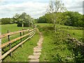
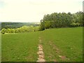
Footpath to Dawson Wood, Thackley
The path here is passing the site of the row of houses called Hill Top.
Image: © Humphrey Bolton
Taken: 12 May 2022
0.08 miles
3
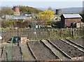
Tunnel vent shafts, Thackley
Looking across some allotments.
Image: © Humphrey Bolton
Taken: 23 Mar 2011
0.09 miles
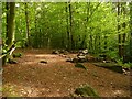
4
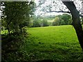
Open area in Dawson Wood, Thackley
Seen from the path that goes around the western edge of the wood. The area is covered with brambles.
Image: © Humphrey Bolton
Taken: 12 May 2022
0.10 miles
5
Footpath to Dawson Wood, Thackley
This is Bradford North non-definitive Footpath 91, non-definitive despite being paved with stone flags
Image: © Humphrey Bolton
Taken: 12 May 2022
0.10 miles
6
The Nosegay, Thackley
A little hill with a triangulation pillar.
Image: © Humphrey Bolton
Taken: 23 Mar 2011
0.10 miles
7
Park Road Allotments, off Amblers Croft, Thackley
This land led to a row of houses called Hill Top. It is now a footpath to Dawson Wood.
Image: © Humphrey Bolton
Taken: 12 May 2022
0.11 miles
8
Tunnel vent shaft, Thackley
Seen from the edge of Dawson Wood.
Image: © Humphrey Bolton
Taken: 12 May 2022
0.11 miles
9
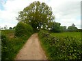
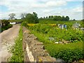
The lane to the site of Hill Top, Thackley
Hill Top was a row of houses, demolished long ago. The lane is now used for access to fields and as a footpath to Dawson Wood, Bradford North non-definitive Footpath 91.
Image: © Humphrey Bolton
Taken: 12 May 2022
0.12 miles
10
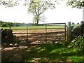
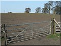
Gateway to a field, Thackley
What caught my eye was that the right-hand gatepost was cut from a disused telephone pole, evidenced by the inscription BT/8L/84.
Image: © Humphrey Bolton
Taken: 12 May 2022
0.12 miles