IMAGES TAKEN NEAR TO
Brackendale Drive, BRADFORD, BD10 0SS
Introduction
This page details the photographs taken nearby to Brackendale Drive, BD10 0SS by members of the Geograph project.
The Geograph project started in 2005 with the aim of publishing, organising and preserving representative images for every square kilometre of Great Britain, Ireland and the Isle of Man.

There are currently over 7.5m images from over14,400 individuals and you can help contribute to the project by visiting https://www.geograph.org.uk
Image Map
Images are licensed for reuse under creativecommons.org/licenses/by-sa/2.0
Notes
- Clicking on the map will re-center to the selected point.
- The higher the marker number, the further away the image location is from the centre of the postcode.
Image Listing (71 Images Found)
Images are licensed for reuse under creativecommons.org/licenses/by-sa/2.0
Image
Details
Distance
1
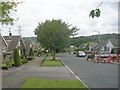
Brackendale Parade - looking towards Brackendale Drive
Image: © Betty Longbottom
Taken: 11 Jul 2011
0.05 miles
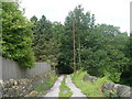
2

Line of Dismantled Railway - off Windhill Old Road
Image: © Betty Longbottom
Taken: 11 Jul 2011
0.08 miles
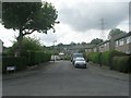
4

Brackendale Parade - Brackendale Drive
Image: © Betty Longbottom
Taken: 11 Jul 2011
0.09 miles
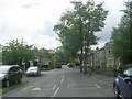
5

Windhill Old Road - viewed from Cyprus Avenue
Image: © Betty Longbottom
Taken: 11 Jul 2011
0.10 miles
6
Frederick Close - Windhill Old Road
Image: © Betty Longbottom
Taken: 11 Jul 2011
0.10 miles
8

Windhill Old Road - viewed from Cyprus Avenue
Image: © Betty Longbottom
Taken: 11 Jul 2011
0.10 miles
9
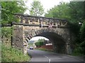
Bridge BRB SH? 31 - Windhill Old Road
This bridge carried a now dismantled line over Windhill Old Road
Image: © Betty Longbottom
Taken: 11 Jul 2011
0.12 miles
10

Brackendale Drive - Windhill Old Road
Image: © Betty Longbottom
Taken: 11 Jul 2011
0.12 miles