IMAGES TAKEN NEAR TO
Weavers Croft, BRADFORD, BD10 0RQ
Introduction
This page details the photographs taken nearby to Weavers Croft, BD10 0RQ by members of the Geograph project.
The Geograph project started in 2005 with the aim of publishing, organising and preserving representative images for every square kilometre of Great Britain, Ireland and the Isle of Man.

There are currently over 7.5m images from over14,400 individuals and you can help contribute to the project by visiting https://www.geograph.org.uk
Image Map
Images are licensed for reuse under creativecommons.org/licenses/by-sa/2.0
Notes
- Clicking on the map will re-center to the selected point.
- The higher the marker number, the further away the image location is from the centre of the postcode.
Image Listing (133 Images Found)
Images are licensed for reuse under creativecommons.org/licenses/by-sa/2.0
Image
Details
Distance
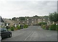
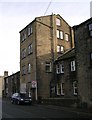
2
Thackley Road
I think the four-storey building was part of Bowling Green Mills.
Image: © Humphrey Bolton
Taken: 23 Jul 2010
0.02 miles
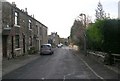
4
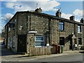
The Ainsbury micropub, Crag Hill Road
This looks as if it was originally a corner shop rather than a pub.
Image: © Stephen Craven
Taken: 5 Apr 2021
0.04 miles
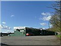
7
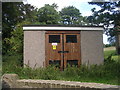
Electricity Substation No 964 - Park Road
Image: © Betty Longbottom
Taken: 24 Aug 2011
0.05 miles
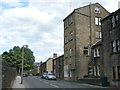
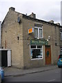
8
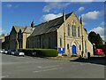
Thackley Methodist Church
The church on Thackley Road dates from 1888.
Image: © Stephen Craven
Taken: 5 Apr 2021
0.05 miles