IMAGES TAKEN NEAR TO
Apperley Road, BRADFORD, BD10 0PU
Introduction
This page details the photographs taken nearby to Apperley Road, BD10 0PU by members of the Geograph project.
The Geograph project started in 2005 with the aim of publishing, organising and preserving representative images for every square kilometre of Great Britain, Ireland and the Isle of Man.

There are currently over 7.5m images from over14,400 individuals and you can help contribute to the project by visiting https://www.geograph.org.uk
Image Map
Images are licensed for reuse under creativecommons.org/licenses/by-sa/2.0
Notes
- Clicking on the map will re-center to the selected point.
- The higher the marker number, the further away the image location is from the centre of the postcode.
Image Listing (278 Images Found)
Images are licensed for reuse under creativecommons.org/licenses/by-sa/2.0
Image
Details
Distance
1
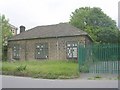
Greengates Water Pumping Station - Apperley Road
Image: © Betty Longbottom
Taken: 7 Jun 2011
0.01 miles
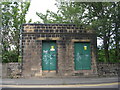
2
Apperley Road wastewater pumping station
The building is shown on the 1921 1:10,560 map and appears still to be in use.
Image: © Stephen Craven
Taken: 24 Mar 2021
0.01 miles
3
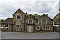
Formerly The George & Dragon
Grade II listed. https://historicengland.org.uk/listing/the-list/list-entry/1314323
Image: © N Chadwick
Taken: 5 May 2019
0.02 miles
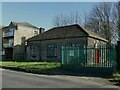
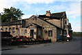
4
Substation on Apperley Road
The building looks relatively old, and may well be the same one shown on the 1936 map.
Image: © Stephen Craven
Taken: 24 Mar 2021
0.02 miles
5
Electricity Substation No 11 - Apperley Road
Image: © Betty Longbottom
Taken: 7 Jun 2011
0.02 miles
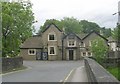
7
Apperley Bridge: The 'George and Dragon'
Very busy and popular pub and restaurant, not a very long drive away from Bradford City Centre.
Image: © Dr Neil Clifton
Taken: 13 Oct 2012
0.02 miles
8
The George and Dragon, Greengates
The pub is located at the southern end of the original Apperley Bridge and dates from the 16th century. It is grade II listed (list entry 1314323).
Image: © Stephen Craven
Taken: 24 Mar 2021
0.02 miles
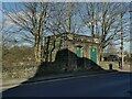
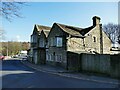
9
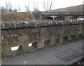
Holes in the wall opposite George and Dragon pub, Apperley Bridge
These holes are presumably to allow any flooding from the River Aire to drain quickly back into the river again. Beyond is the dreary concrete bridge built in the 1930s. Before this the only way to cross the river at this point was the much older stone bridge opposite the George and Dragon.
Image: © Linden Milner
Taken: 28 Feb 2014
0.03 miles
10

Environment Agency Bench Mark
This mark can be found on the 'old' Apperley Bridge.
Image: © Peter Wood
Taken: 23 Apr 2012
0.03 miles