IMAGES TAKEN NEAR TO
The Strone, BRADFORD, BD10 0NZ
Introduction
This page details the photographs taken nearby to The Strone, BD10 0NZ by members of the Geograph project.
The Geograph project started in 2005 with the aim of publishing, organising and preserving representative images for every square kilometre of Great Britain, Ireland and the Isle of Man.

There are currently over 7.5m images from over14,400 individuals and you can help contribute to the project by visiting https://www.geograph.org.uk
Image Map
Images are licensed for reuse under creativecommons.org/licenses/by-sa/2.0
Notes
- Clicking on the map will re-center to the selected point.
- The higher the marker number, the further away the image location is from the centre of the postcode.
Image Listing (124 Images Found)
Images are licensed for reuse under creativecommons.org/licenses/by-sa/2.0
Image
Details
Distance
1
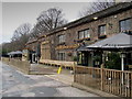
The Stansfield Arms, Apperley Bridge
Fine and well established hostelry in Apperley Bridge on the A658. My wife and I shared our second date here, many years ago.
Image: © Chris Heaton
Taken: 19 Feb 2014
0.01 miles
2
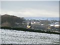
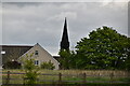
Distant view of Woodhouse Grove Methodist Church
Looking across snowy fields to the spire of Image, and the buildings of Woodhouse Grove School which are slightly nearer.
Taken from the bank of the Leeds & Liverpool Canal, by Lodge Wood, about 1.3 km from the church.
Image: © Rich Tea
Taken: 7 Feb 2009
0.01 miles
4
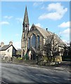
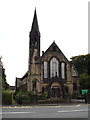
Woodhouse Grove Methodist Church and School Chapel, Apperley Lane, Rawdon
This is a listed building, built in 1887.
Image: © Humphrey Bolton
Taken: 3 Feb 2011
0.01 miles
5
Apperley Bridge: Woodhouse Grove Methodist Church
Not many Methodist churches have spires: this particular church also serves as the Chapel for the nearby Woodhouse Grove School.
Image: © Dr Neil Clifton
Taken: 13 Oct 2012
0.01 miles
6
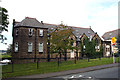
Apperley Bridge: Former Sunday School
Clearly built to harmonise with the church on the opposite side of the road, but the aspect spoiled by the ugly block at the left hand end, which surely must have been a later addition. Some years ago, it was sold and has now been converted for residential use.
Image: © Dr Neil Clifton
Taken: 13 Oct 2012
0.02 miles
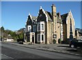
10
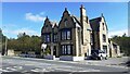
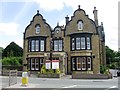
Former Queen's Hotel on east side of Apperley Lane for sale
There is an Ordnance Survey benchmark Image on the road end of the wall next to the lamppost near the left hand edge of the image
Image: © Roger Templeman
Taken: 3 Sep 2024
0.04 miles