IMAGES TAKEN NEAR TO
Ranelagh Avenue, BRADFORD, BD10 0HF
Introduction
This page details the photographs taken nearby to Ranelagh Avenue, BD10 0HF by members of the Geograph project.
The Geograph project started in 2005 with the aim of publishing, organising and preserving representative images for every square kilometre of Great Britain, Ireland and the Isle of Man.

There are currently over 7.5m images from over14,400 individuals and you can help contribute to the project by visiting https://www.geograph.org.uk
Image Map
Images are licensed for reuse under creativecommons.org/licenses/by-sa/2.0
Notes
- Clicking on the map will re-center to the selected point.
- The higher the marker number, the further away the image location is from the centre of the postcode.
Image Listing (58 Images Found)
Images are licensed for reuse under creativecommons.org/licenses/by-sa/2.0
Image
Details
Distance
2
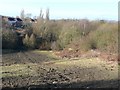
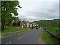
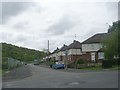
Field and woodland near Low Rein
The woodland surrounds an old reservoir. Some of the houses in the older part of the Ravenscliffe housing estate, on Ranalagh Avenue, can be seen.
Image: © Humphrey Bolton
Taken: 3 Feb 2011
0.07 miles
3
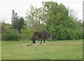
Horse grazing - off Ranelagh Avenue
Image: © Betty Longbottom
Taken: 26 Apr 2011
0.08 miles
5
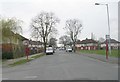
Damon Avenue - viewed from Norbury Road
Image: © Betty Longbottom
Taken: 26 Mar 2011
0.10 miles
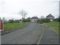
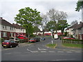
7
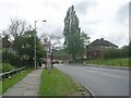
Ranelagh Avenue - viewed from Roundwood Glen
Image: © Betty Longbottom
Taken: 26 Apr 2011
0.11 miles
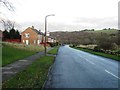
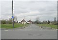
10
Ranelagh Avenue - viewed from Roundwood Glen
Image: © Betty Longbottom
Taken: 26 Apr 2011
0.11 miles