IMAGES TAKEN NEAR TO
Rokeby Gardens, BRADFORD, BD10 0DN
Introduction
This page details the photographs taken nearby to Rokeby Gardens, BD10 0DN by members of the Geograph project.
The Geograph project started in 2005 with the aim of publishing, organising and preserving representative images for every square kilometre of Great Britain, Ireland and the Isle of Man.

There are currently over 7.5m images from over14,400 individuals and you can help contribute to the project by visiting https://www.geograph.org.uk
Image Map
Images are licensed for reuse under creativecommons.org/licenses/by-sa/2.0
Notes
- Clicking on the map will re-center to the selected point.
- The higher the marker number, the further away the image location is from the centre of the postcode.
Image Listing (108 Images Found)
Images are licensed for reuse under creativecommons.org/licenses/by-sa/2.0
Image
Details
Distance
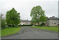
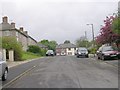
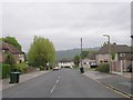
3
Rimswell Holt - viewed from Redcar Road
Image: © Betty Longbottom
Taken: 5 May 2009
0.05 miles
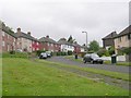
5
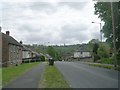
Rimswell Holt - viewed from near Redcar Road
Image: © Betty Longbottom
Taken: 26 Apr 2011
0.06 miles
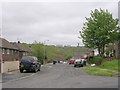
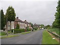
6
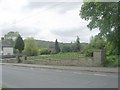
Site of the former St Brendan's Catholic Church - Rimswell Holt
This church was demolished following a reorganisation of parishes within the Diocese of Leeds.
Image: © Betty Longbottom
Taken: 26 Apr 2011
0.06 miles
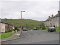
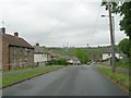
9
Roundwood Glen - viewed from Roundwood View
Image: © Betty Longbottom
Taken: 5 May 2009
0.08 miles