IMAGES TAKEN NEAR TO
Sulby Grove, BRADFORD, BD10 0DB
Introduction
This page details the photographs taken nearby to Sulby Grove, BD10 0DB by members of the Geograph project.
The Geograph project started in 2005 with the aim of publishing, organising and preserving representative images for every square kilometre of Great Britain, Ireland and the Isle of Man.

There are currently over 7.5m images from over14,400 individuals and you can help contribute to the project by visiting https://www.geograph.org.uk
Image Map
Images are licensed for reuse under creativecommons.org/licenses/by-sa/2.0
Notes
- Clicking on the map will re-center to the selected point.
- The higher the marker number, the further away the image location is from the centre of the postcode.
Image Listing (167 Images Found)
Images are licensed for reuse under creativecommons.org/licenses/by-sa/2.0
Image
Details
Distance
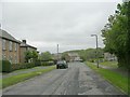
4
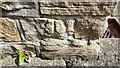
Benchmark on #17 Roans Brae
Ordnance Survey cut mark benchmark levelled at 99.340m above Newlyn Datum verified 1957
Image: © Roger Templeman
Taken: 18 Aug 2024
0.04 miles
6
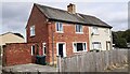
Nos. 17 and 19 Roans Brae
There is an Ordnance Survey benchmark Image on the near corner, left hand face, of the left hand house
Image: © Roger Templeman
Taken: 18 Aug 2024
0.05 miles

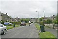
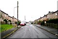
10
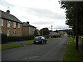
Roans Brae, Greengates
Off Redcar Road.
Image: © Richard Vince
Taken: 15 Sep 2022
0.06 miles