IMAGES TAKEN NEAR TO
Bateson Street, BRADFORD, BD10 0BE
Introduction
This page details the photographs taken nearby to Bateson Street, BD10 0BE by members of the Geograph project.
The Geograph project started in 2005 with the aim of publishing, organising and preserving representative images for every square kilometre of Great Britain, Ireland and the Isle of Man.

There are currently over 7.5m images from over14,400 individuals and you can help contribute to the project by visiting https://www.geograph.org.uk
Image Map
Images are licensed for reuse under creativecommons.org/licenses/by-sa/2.0
Notes
- Clicking on the map will re-center to the selected point.
- The higher the marker number, the further away the image location is from the centre of the postcode.
Image Listing (162 Images Found)
Images are licensed for reuse under creativecommons.org/licenses/by-sa/2.0
Image
Details
Distance
2
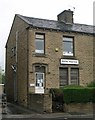
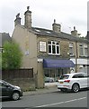
Dental Practice - New Line, Greengates
Image: © Betty Longbottom
Taken: 16 May 2007
0.04 miles
4
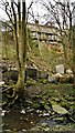
Rear of houses on Carr Bottom Road
Challenging gardens to maintain, and a local tip in the Carr Beck below!
Image: © Chris Morgan
Taken: 17 Mar 2014
0.05 miles
5
Ginger's Hair, Nails & Beauty - New Line
Image: © Betty Longbottom
Taken: 7 Jun 2011
0.05 miles
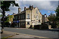
6
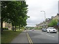
New Line - viewed from Carr Bottom Road
Image: © Betty Longbottom
Taken: 7 Jun 2011
0.05 miles