IMAGES TAKEN NEAR TO
Regent Street, NELSON, BB9 7QX
Introduction
This page details the photographs taken nearby to Regent Street, BB9 7QX by members of the Geograph project.
The Geograph project started in 2005 with the aim of publishing, organising and preserving representative images for every square kilometre of Great Britain, Ireland and the Isle of Man.

There are currently over 7.5m images from over14,400 individuals and you can help contribute to the project by visiting https://www.geograph.org.uk
Image Map
Images are licensed for reuse under creativecommons.org/licenses/by-sa/2.0
Notes
- Clicking on the map will re-center to the selected point.
- The higher the marker number, the further away the image location is from the centre of the postcode.
Image Listing (84 Images Found)
Images are licensed for reuse under creativecommons.org/licenses/by-sa/2.0
Image
Details
Distance
1
"Ace Beds UK" Unit 8, Throstle Nest Mill, Leeds Road, Nelson, Lancashire BB9 9XG
Image: © Robert Wade
Taken: 19 May 2011
0.04 miles
2
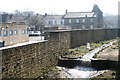
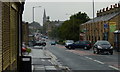
The Goit, Nelson, Lancashire
Looking upstream along The Goit, or Walverden Water to give it its proper name, as it flows through the centre of Nelson. Local youths have decided to beautify it by the addition of a shopping trolley from the nearby Tesco store.
In the background, the 'Prince of Wales' on Leeds Road is seen.
Image: © Dr Neil Clifton
Taken: 19 Mar 2009
0.08 miles
3
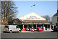
Maria's Cash and Carry, Bradley Road, Nelson
An obviously popular outlet with particularly good stocks of fresh fruit and vegetables
Image: © Dr Neil Clifton
Taken: 19 Mar 2009
0.08 miles
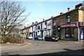
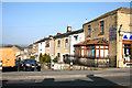
4
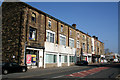
Shops, Leeds Road, Nelson, Lancashire
This substantial stone-built three-storey block may always have been intended to be shops. Just opposite is St. Philip's Church.
Image: © Dr Neil Clifton
Taken: 19 Mar 2009
0.09 miles
6
Walton Street, Nelson, Lancashire
This small street was built in 1862 and is now occupied by people of many ethnic origins. In the middle is an Irish club.
Image: © Dr Neil Clifton
Taken: 19 Mar 2009
0.10 miles
7
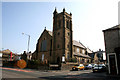
St. Philip's Church, Leeds Road, Nelson, Lancashire
This building is probably not in use for services, as signs outside proclaim it to be the Grass Roots Family Centre.
Image: © Dr Neil Clifton
Taken: 19 Mar 2009
0.10 miles
8
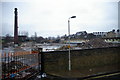
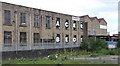
Riverside Mill
The remains of part of Britain's greatness, the chimney is now used as mobile phone mast, the interior whitewash paint on the mill wall, makes an interesting pattern. Some way along the line the mill must have had a name change, behind all the antenna etc is the original name which was BRADLEY SHED
Image: © Alexander P Kapp
Taken: 10 Jan 2006
0.11 miles
9
Bradley Road, Nelson, Lancashire
Bradley Road runs north-westwards from Leeds Road before turning west to meet Scotland Road. As it used to be used for 'rat-running', the Leeds Road end is now closed off to traffic.
Image: © Dr Neil Clifton
Taken: 19 Mar 2009
0.11 miles
10
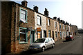
Harvey Street, Nelson, Lancashire
Nos. 2 to 24 (evens). The houses on this street, apart from Nos. 2 and 4, remain in full occupation.
Image: © Dr Neil Clifton
Taken: 19 Mar 2009
0.11 miles