IMAGES TAKEN NEAR TO
Norfolk Street, NELSON, BB9 7FG
Introduction
This page details the photographs taken nearby to Norfolk Street, BB9 7FG by members of the Geograph project.
The Geograph project started in 2005 with the aim of publishing, organising and preserving representative images for every square kilometre of Great Britain, Ireland and the Isle of Man.

There are currently over 7.5m images from over14,400 individuals and you can help contribute to the project by visiting https://www.geograph.org.uk
Image Map (Loading...)


Getting Data...Please wait
Leaflet Map data © OpenStreetMap
Images are licensed for reuse under creativecommons.org/licenses/by-sa/2.0
Notes
- Clicking on the map will re-center to the selected point.
- The higher the marker number, the further away the image location is from the centre of the postcode.
Image Listing (176 Images Found)
Images are licensed for reuse under creativecommons.org/licenses/by-sa/2.0
Image
Details
Distance
2

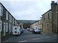
Carr Road, Nelson, Lancashire
Carr Road is part of the B6249 and runs westward out of Nelson, connecting it with the Pendleside villages such as Fence and Higham. The terrace houses here are fully occupied and well-maintained, contrasting with the situation in the Whitefield area just to the south. Here, the street which crosses at right angles is Norfolk Street, while further down is the bridge carrying the M65, with a Warburton's bread van (a common sight in Lancashire) travelling south.
Image: © Dr Neil Clifton
Taken: 9 Dec 2008
0.03 miles
3
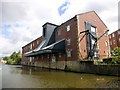
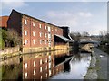
Leeds And Liverpool Canal Warehouse, Nelson
This canal warehouse was built around 1876 for the Leeds-Liverpool Canal Company. It is a grade II listed building.
Image: © Rude Health
Taken: 18 Jul 2015
0.04 miles
4
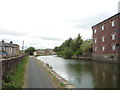
Leeds and Liverpool Canal north of Carr Road Bridge
Image: © JThomas
Taken: 2 Aug 2018
0.04 miles
5
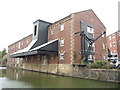
Loading Bay Canopy, Leeds and Liverpool Canal Warehouse, Nelson
This canal warehouse, dating from ca1876, was one of nine new warehouses built for the Leeds-Liverpool Canal Company between 1874 and 1879 at various places between Leeds and Liverpool.
See also Image],
Image] and
Image
Image: © David Dixon
Taken: 19 Mar 2015
0.04 miles
6
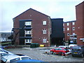
Mill conversion beside the Leeds & Liverpool Canal
Image: © JThomas
Taken: 2 Aug 2018
0.04 miles
7
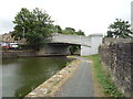
Carr Road Bridge over the Leeds and Liverpool Canal
Image: © JThomas
Taken: 2 Aug 2018
0.04 miles
8
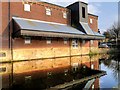
Leeds and Liverpool Canal Warehouse, Nelson
This canal warehouse, dating from ca1876, was one of nine new warehouses built for the Leeds-Liverpool Canal Company between 1874 and 1879 at various places between Leeds and Liverpool.
See also Image],
Image] and
Image
The three storey warehouse is of red brick in English bond, with sandstone quoins and dressings plinth of large dressed sandstone blocks, and slate roof. It has an almost rectangular plan, lying parallel to and immediately adjoining the canal. There is a pitched canopy at 1st-floor.
It is a grade II listed building (English Heritage Building ID: 448306 http://www.britishlistedbuildings.co.uk/en-448306-leeds-and-liverpool-canal-warehouse-nels British Listed Buildings).
Image: © David Dixon
Taken: 19 Mar 2015
0.05 miles
10
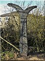
National Cycle Network Milestone
On route No.68 by the Leeds & Liverpool Canal
Image: © Kevin Waterhouse
Taken: 6 Feb 2023
0.05 miles