IMAGES TAKEN NEAR TO
Carr Hall Road, NELSON, BB9 6QG
Introduction
This page details the photographs taken nearby to Carr Hall Road, BB9 6QG by members of the Geograph project.
The Geograph project started in 2005 with the aim of publishing, organising and preserving representative images for every square kilometre of Great Britain, Ireland and the Isle of Man.

There are currently over 7.5m images from over14,400 individuals and you can help contribute to the project by visiting https://www.geograph.org.uk
Image Map
Images are licensed for reuse under creativecommons.org/licenses/by-sa/2.0
Notes
- Clicking on the map will re-center to the selected point.
- The higher the marker number, the further away the image location is from the centre of the postcode.
Image Listing (7 Images Found)
Images are licensed for reuse under creativecommons.org/licenses/by-sa/2.0
Image
Details
Distance
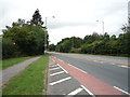
1
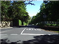
Carr Hall Road
Looking down Carr Hall Road from its junction with Wheatley Lane Road
Image: © Alexander P Kapp
Taken: 2 Jun 2006
0.07 miles
2
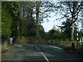
Wheatley Lane Road/Carr Hall Road junction
Image: © Colin Pyle
Taken: 7 Feb 2015
0.10 miles
3
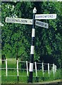
Direction Sign ? Signpost in Barrowford
Located on the south side of the T junction of Wheatley Lane and Carr Hall Road in Barrowford parish. 3 arms and cup & bell finial.
Milestone Society National ID: LA_SD8438
Image: © D Armstrong
Taken: Unknown
0.10 miles
4

Entrance to All Souls RC Cemetery
The chapel in the graveyard was demolished in 2004.
Image: © Alexander P Kapp
Taken: 2 Jun 2006
0.14 miles
7
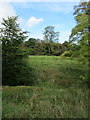
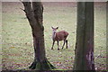
Looking towards Higgen Clough
Passed this scene while descending from Wheatley Lane towards Pendle Water at Lomeshaye.
Image: © Chris Heaton
Taken: 9 Oct 2012
0.24 miles