IMAGES TAKEN NEAR TO
Pasture Lane, NELSON, BB9 6PF
Introduction
This page details the photographs taken nearby to Pasture Lane, BB9 6PF by members of the Geograph project.
The Geograph project started in 2005 with the aim of publishing, organising and preserving representative images for every square kilometre of Great Britain, Ireland and the Isle of Man.

There are currently over 7.5m images from over14,400 individuals and you can help contribute to the project by visiting https://www.geograph.org.uk
Image Map
Images are licensed for reuse under creativecommons.org/licenses/by-sa/2.0
Notes
- Clicking on the map will re-center to the selected point.
- The higher the marker number, the further away the image location is from the centre of the postcode.
Image Listing (13 Images Found)
Images are licensed for reuse under creativecommons.org/licenses/by-sa/2.0
Image
Details
Distance
1
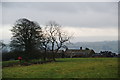
Higher Ridge Farm
In a commanding position on the end of the ridge, with views over and beyond Colne.
Image: © Bill Boaden
Taken: 27 Dec 2011
0.03 miles
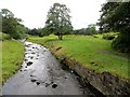
2
Pasture by Water Meetings
A view from the Pendle Way long distance footpath, just to the south of Water Meetings.
Image: © Chris Heaton
Taken: 9 Oct 2012
0.15 miles
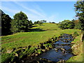
3
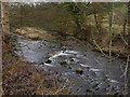
Waters Meeting
The Blacko Water joins Pendle Water, view from the Pendle Way
Image: © Raymond Knapman
Taken: 11 Jun 2018
0.18 miles
4
Pendle Water near Blacko
Blacko Water joins the larger Pendle Water here.
Image: © philandju
Taken: 18 Aug 2014
0.19 miles
5
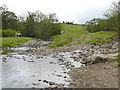
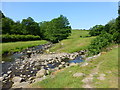
Water Meetings
The confluence of the two streams, Pendle Water to the left and Blacko Water to the right is locally known as the Water Meetings. A nearby cottage also bears the name.
Image: © Chris Tomlinson
Taken: 27 May 2010
0.19 miles
6
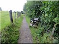
Rest a while
Bench on the Pendle Way near Blacko.
Image: © philandju
Taken: 18 Aug 2014
0.19 miles
7
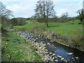
Pendle Water
The Pendle Way next to Pendle Water west of Blacko. A beautiful walk with much varied birdlife. On the April morning we saw an owl, a woodpecker, a dipper and a curlew all within about half an hour of setting off on the Pendle Way.
Image: © R Greenhalgh
Taken: 28 Apr 2010
0.19 miles
8
Blacko Water
The watercourse just before it empties into Pendle Water - Pendle Way long distance footpath follows its right bank for a few yards before crossing to head towards Blacko Foot.
Image: © Chris Heaton
Taken: 9 Oct 2012
0.20 miles
9

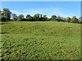
Hillside down to Pendle Water
Pendle Water can be seen flowing at the bottom. This is the north east end of the Rigg of England ridge.
Image: © Bill Boaden
Taken: 27 Dec 2011
0.21 miles