IMAGES TAKEN NEAR TO
Wheathead Lane, NELSON, BB9 6PB
Introduction
This page details the photographs taken nearby to Wheathead Lane, BB9 6PB by members of the Geograph project.
The Geograph project started in 2005 with the aim of publishing, organising and preserving representative images for every square kilometre of Great Britain, Ireland and the Isle of Man.

There are currently over 7.5m images from over14,400 individuals and you can help contribute to the project by visiting https://www.geograph.org.uk
Image Map
Images are licensed for reuse under creativecommons.org/licenses/by-sa/2.0
Notes
- Clicking on the map will re-center to the selected point.
- The higher the marker number, the further away the image location is from the centre of the postcode.
Image Listing (8 Images Found)
Images are licensed for reuse under creativecommons.org/licenses/by-sa/2.0
Image
Details
Distance
3
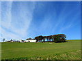
Height House
As seen from the track below the buildings, just to the north of Wheathead Lane
Image: © Chris Heaton
Taken: 9 Oct 2012
0.18 miles
5
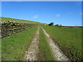
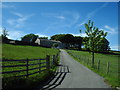
Track leading to Jackson's House
Track heading away from Wheathead Lane towards Jackson's House and Rimington Moor.
Image: © Chris Heaton
Taken: 9 Oct 2012
0.22 miles
6
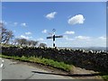
Old Direction Sign - Signpost by Wheathead Lane, Roughlee Booth parish
Annulus finial - 3 arms; in parish of Roughlee Booth (Pendle District), North of Stang Top, Roughlee, behind dry stone wall, East side of road.
Surveyed
Milestone Society National ID: LA_SD8341
Image: © Milestone Society
Taken: Unknown
0.23 miles
7
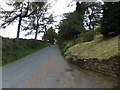
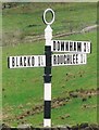
Lane junction near Roughlee
Wheathead Lane meets Black Moss Road. Possible destinations are Downham, Blacko and Roughlee.
Image: © philandju
Taken: 19 Apr 2016
0.24 miles
8
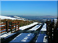
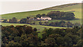
Cattle grid and snowy access road
Blacko Tower on the horizon.
Image: © John H Darch
Taken: 28 Jan 2012
0.24 miles