IMAGES TAKEN NEAR TO
Sykefield, NELSON, BB9 5NB
Introduction
This page details the photographs taken nearby to Sykefield, BB9 5NB by members of the Geograph project.
The Geograph project started in 2005 with the aim of publishing, organising and preserving representative images for every square kilometre of Great Britain, Ireland and the Isle of Man.

There are currently over 7.5m images from over14,400 individuals and you can help contribute to the project by visiting https://www.geograph.org.uk
Image Map
Images are licensed for reuse under creativecommons.org/licenses/by-sa/2.0
Notes
- Clicking on the map will re-center to the selected point.
- The higher the marker number, the further away the image location is from the centre of the postcode.
Image Listing (89 Images Found)
Images are licensed for reuse under creativecommons.org/licenses/by-sa/2.0
Image
Details
Distance
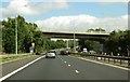
1
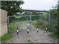
Brierfield Entrance To Old Water Works
Gates at the entrance to the old water works in Brierfield the motorway bridge carries the road from Brierfield to Fence over the M65
Image: © Paul Best
Taken: 17 Sep 2004
0.03 miles
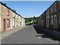
3
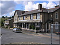
Houses on Clitheroe Road, Brierfield
When the M65 motorway was built, it was necessary to divert Clitheroe Road (the B6248) slightly to the south to make easier the construction of a bridge for this road over the motorway. Thus these houses were left slightly off the new alignment of the B6248, which diverged from the old alignment about where the photographer is standing.
Image: © Dr Neil Clifton
Taken: 15 Jul 2009
0.06 miles
4
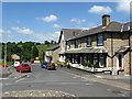
Clitheroe Road, Brierfield
This is now the B6248 linking Brierfield with the Pendleside villages, (Fence, Wheatley Lane, etc). Formerly the road was known as Lob Lane, and gave this name to the bridge, still so called, over the Leeds and Liverpool Canal
Image: © Dr Neil Clifton
Taken: 9 Jun 2008
0.07 miles
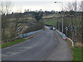
5
Clitheroe Road crosses the M65 near Brierfield
Image: © Steve Daniels
Taken: 28 Aug 2014
0.09 miles
7
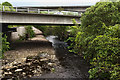
Pendle Water passes under the M65 and B6248
Image: © Ian Greig
Taken: 27 May 2016
0.10 miles
8
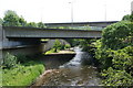
Bridges over Pendle Water
The higher bridge is Clitheroe Road, Brierfield while the central one carries the M65 motorway. This view is taken from Quaker Bridge.
Image: © Bill Boaden
Taken: 4 Jun 2011
0.10 miles
9
The western approach to Brierfield
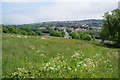
Taken from Cuckstool Lane. The road, the B6248 crosses the M65, visible below, before entering the town. The prominent landmarks are a mill and a mosque.
Image: © Bill Boaden
Taken: 4 Jun 2011
0.11 miles
10
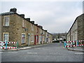
Belgrave Street, Brierfield
Soon to be demolished to make way for modern houses
Image: © Alexander P Kapp
Taken: 14 Feb 2008
0.11 miles