IMAGES TAKEN NEAR TO
Hey Houses, CLITHEROE, BB7 9EJ
Introduction
This page details the photographs taken nearby to Hey Houses, BB7 9EJ by members of the Geograph project.
The Geograph project started in 2005 with the aim of publishing, organising and preserving representative images for every square kilometre of Great Britain, Ireland and the Isle of Man.

There are currently over 7.5m images from over14,400 individuals and you can help contribute to the project by visiting https://www.geograph.org.uk
Image Map (Loading...)


Getting Data...Please wait
Leaflet Map data © OpenStreetMap
Images are licensed for reuse under creativecommons.org/licenses/by-sa/2.0
Notes
- Clicking on the map will re-center to the selected point.
- The higher the marker number, the further away the image location is from the centre of the postcode.
Image Listing (57 Images Found)
Images are licensed for reuse under creativecommons.org/licenses/by-sa/2.0
Image
Details
Distance
1
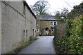
Hey Houses
A quiet corner of Sabden. This lane serves about 3 farms and the reservoir.
Image: © Bill Boaden
Taken: 19 Feb 2011
0.01 miles
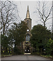
3
Parish church of St. Nicholas at Sabden
Image: © Raymond Knapman
Taken: 10 Mar 2014
0.05 miles
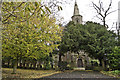
7
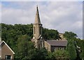
St Nicholas (originally St Simon and St Jude), Sabden
Located on Wesley St and surrounded by trees the Church was founded in 1841 and was still in use when this image was taken.
Image: © Steve Houldsworth
Taken: Unknown
0.07 miles
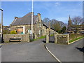
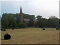
8
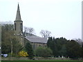
The Parish of Sabden St Nicholas Heyhouses
Image: © Alexander P Kapp
Taken: 20 Apr 2007
0.08 miles
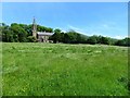
9
Morning view of the parish church
Whilst not in the foreground, there was a lot of morning mist.
Image: © Bill Boaden
Taken: 9 Jun 2007
0.08 miles
10

Sabden Village near Clitheroe
The village of Sabden as seen from Back Lane. The road out of the village travels onto Clitheroe and is known locally as the "Nick o Pendle" as it traverses the spine of the famous hill. This is the heart of Lancashire Witch Country.
Image: © mark belshaw
Taken: 12 Sep 2009
0.08 miles