IMAGES TAKEN NEAR TO
Higher Chapel Lane, CLITHEROE, BB7 4RJ
Introduction
This page details the photographs taken nearby to Higher Chapel Lane, BB7 4RJ by members of the Geograph project.
The Geograph project started in 2005 with the aim of publishing, organising and preserving representative images for every square kilometre of Great Britain, Ireland and the Isle of Man.

There are currently over 7.5m images from over14,400 individuals and you can help contribute to the project by visiting https://www.geograph.org.uk
Image Map
Images are licensed for reuse under creativecommons.org/licenses/by-sa/2.0
Notes
- Clicking on the map will re-center to the selected point.
- The higher the marker number, the further away the image location is from the centre of the postcode.
Image Listing (23 Images Found)
Images are licensed for reuse under creativecommons.org/licenses/by-sa/2.0
Image
Details
Distance
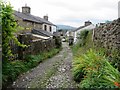
1
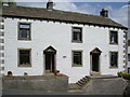
Stonehill Cottages, Main Street, Grindleton
Image: © Alexander P Kapp
Taken: 31 May 2007
0.02 miles
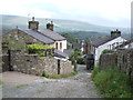
2
Top of Town, Grindleton
The northern and upper part of the village.
Image: © Chris Heaton
Taken: 2 Mar 2010
0.04 miles
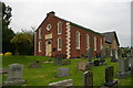
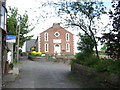
5
Free Methodist Church, Grindleton
At Top of Town in Grindleton.
Image: © philandju
Taken: 28 Sep 2011
0.09 miles
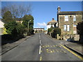
6
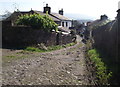
Back Lane, Grindleton
At the area of the village known as Top Of Town.
Image: © philandju
Taken: 28 Sep 2011
0.09 miles
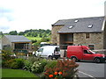
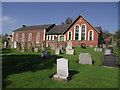
9
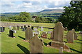
The Methodist Church graveyard, Grindleton
St Ambrose's Church is down below, and the Ribble Valley beyond it.
Image: © Bill Boaden
Taken: 11 Jun 2011
0.10 miles