IMAGES TAKEN NEAR TO
Twitter Lane, CLITHEROE, BB7 3LG
Introduction
This page details the photographs taken nearby to Twitter Lane, BB7 3LG by members of the Geograph project.
The Geograph project started in 2005 with the aim of publishing, organising and preserving representative images for every square kilometre of Great Britain, Ireland and the Isle of Man.

There are currently over 7.5m images from over14,400 individuals and you can help contribute to the project by visiting https://www.geograph.org.uk
Image Map
Images are licensed for reuse under creativecommons.org/licenses/by-sa/2.0
Notes
- Clicking on the map will re-center to the selected point.
- The higher the marker number, the further away the image location is from the centre of the postcode.
Image Listing (14 Images Found)
Images are licensed for reuse under creativecommons.org/licenses/by-sa/2.0
Image
Details
Distance
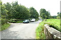
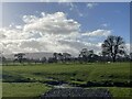
1
Approaching Wetters Bridge
A Grade II listed structure on Twitter Lane spanning Bashall Brook to the south west of Waddington.
Image: © philandju
Taken: 8 Jul 2022
0.01 miles
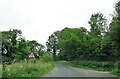
2
Wetter's Bridge
On Twitter Lane, near Waddington.
Image: © philandju
Taken: 30 Apr 2013
0.01 miles
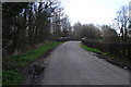
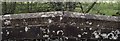
4
Twitter Bridge Farm Ford
This is a farm field access ford at Twitter Bridge Farm.
Image: © John Walton
Taken: 18 Feb 2024
0.06 miles
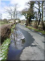
5

Wetters Bridge
The stream is Bashall Brook
Image: © Alexander P Kapp
Taken: 9 Mar 2008
0.06 miles
6
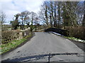
Wetters Bridge
Twitters Lane as it goes over Wetters Bridge
Image: © Alexander P Kapp
Taken: 9 Mar 2008
0.07 miles
7

Wetters Bridge
A grade II listed structure on Twitter Lane outside Waddington.
Image: © philandju
Taken: 8 Jul 2022
0.08 miles
8
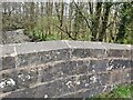
Old Boundary Marker on Wetters Bridge
Bridge Marker inscribed in the east parapet of Wetters Bridge, Bashall Brook, on Twitter Lane. On the boundary of Waddington and Bashall Eaves parishes. Inscribed WETTERS BRIDGE.
Milestone Society National ID: YW_BEAWAD02br
Image: © D Phillips
Taken: Unknown
0.08 miles
9
Old Boundary Marker on Wetters Bridge, Twitter Lane, Bashall Eaves Parish
Parish Boundary Marker by the UC road, in parish of Bashall Eaves (Ribble Valley District), Wetters Bridge, Twitter Lane, bridge parapet, West side of road.
Inscription reads:-
{<-hand} BASHALL EAVES | WADDINGTON {hand->}
Wetters Bridge is Grade II listed.
List Entry Number: 1072200 https://historicengland.org.uk/listing/the-list/list-entry/1072200
To be surveyed
Milestone Society National ID: YW_BEAWAD01pb
Image: © Philip Platt
Taken: 1 Apr 2013
0.08 miles