IMAGES TAKEN NEAR TO
Twin Brook Road, CLITHEROE, BB7 1QX
Introduction
This page details the photographs taken nearby to Twin Brook Road, BB7 1QX by members of the Geograph project.
The Geograph project started in 2005 with the aim of publishing, organising and preserving representative images for every square kilometre of Great Britain, Ireland and the Isle of Man.

There are currently over 7.5m images from over14,400 individuals and you can help contribute to the project by visiting https://www.geograph.org.uk
Image Map
Images are licensed for reuse under creativecommons.org/licenses/by-sa/2.0
Notes
- Clicking on the map will re-center to the selected point.
- The higher the marker number, the further away the image location is from the centre of the postcode.
Image Listing (13 Images Found)
Images are licensed for reuse under creativecommons.org/licenses/by-sa/2.0
Image
Details
Distance
1
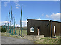
Abandoned golf driving range
Looks like this place hasn't been used for a while.
Image: © Gary Rogers
Taken: 29 Mar 2009
0.05 miles
3
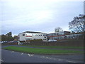
Clitheroe Royal Grammar School (Lower School)
Image: © Charles Rawding
Taken: 29 Oct 2005
0.10 miles
4
Crinoid Fragments - Salthills Quarry
In the disused Salthills limestone quarry face now part of the Salthills Geology Trail
Image: © Gary Rogers
Taken: 29 Mar 2009
0.12 miles
5
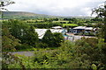
Salthill Industrial Estate
Built on former quarry land.
Image: © Bill Boaden
Taken: 11 Jun 2011
0.17 miles
6
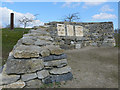
Bench and shelter
Made from the local limestone On the Salthills Geology Trail.
Image: © Gary Rogers
Taken: 29 Mar 2009
0.18 miles
7
Entrance to Salthill Geology Trail
A path follows the disused quarry face at the entrance off Lincoln Way
Image: © Kevin Waterhouse
Taken: 5 Aug 2024
0.20 miles
8
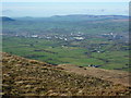
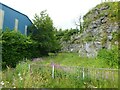
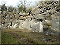
Salthills Quarry Geology Trail
Face of abandoned limestone quarry. The site of the old quarry is now largely occupied by an industrial estate but there is a geology trail running round its perimeter. The limestone contains crinoid fossils, ancient sea cretures that lived around 340 million years ago at a time when this area was under a shallow sea near the equator. Small fragments can be gathered from the surrounding area and in situ examples are clearly visible in the quarry face. A small area of limestone grassland around the quarry is now actively managed for its biodiversity and a geology trail has been laid out.
From a historical perspective, a commemorative plaque on Lincoln Way tells how "All the soil and woods of Salthille was given to the Burgesses of Clitheroe and their heirs to make their profit thereof in the best manner they can" by Henry De Lacy, Earl of Lincoln in 1307.
Image: © Gary Rogers
Taken: 29 Mar 2009
0.20 miles
9
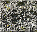
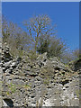
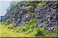
Limestone wall of the old Salthill Quarry
Image: © Peter Bond
Taken: 25 Feb 2013
0.21 miles
10
Salthill Quarry now a nature reserve
This forms part of the Geology Trail http://www.lancswt.org.uk/places-to-see/salthill-quary
Image: © Ian Greig
Taken: 18 Jul 2014
0.22 miles