IMAGES TAKEN NEAR TO
Greenacre Street, CLITHEROE, BB7 1ED
Introduction
This page details the photographs taken nearby to Greenacre Street, BB7 1ED by members of the Geograph project.
The Geograph project started in 2005 with the aim of publishing, organising and preserving representative images for every square kilometre of Great Britain, Ireland and the Isle of Man.

There are currently over 7.5m images from over14,400 individuals and you can help contribute to the project by visiting https://www.geograph.org.uk
Image Map
Images are licensed for reuse under creativecommons.org/licenses/by-sa/2.0
Notes
- Clicking on the map will re-center to the selected point.
- The higher the marker number, the further away the image location is from the centre of the postcode.
Image Listing (314 Images Found)
Images are licensed for reuse under creativecommons.org/licenses/by-sa/2.0
Image
Details
Distance
1
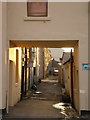
Back street
Off Greenacre Street and runs parallel with Whalley Road
Image: © Alexander P Kapp
Taken: 28 Dec 2008
0.01 miles
4
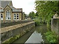
Mearley Brook below Greenacres Street
The brook once powered several water mills in the area.
Image: © Stephen Craven
Taken: 23 Aug 2022
0.01 miles
5
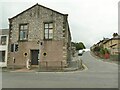
Building on the corner of Turner Street
The building is listed grade II (entry 1362228) and dates from c.1825, but its original and present use are not obvious although the listing refers to a 'carriage entry' on the Turner Street elevation, so it may have served as a 'horse and carriage repository' for the inn that used to stand immediately to the north (left).
Image: © Stephen Craven
Taken: 23 Aug 2022
0.03 miles
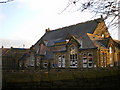
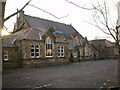
7
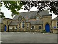
St James C of E Primary School, Greenacres Street, Clitheroe
Image: © Stephen Craven
Taken: 23 Aug 2022
0.04 miles
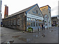
8
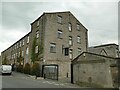
Holmes Mill, Greenacre Street
The buildings further to the right, dating from the 1820s and 1830s, were a textile mill, but the one shown here, now called the Spinning Block, is labelled on the 1912 map as a 'technical school'. The whole site, now a business and leisure complex taking its name from the former mill, was listed Grade II in 2013 and the listing gives a detailed history https://historicengland.org.uk/listing/the-list/list-entry/1413649?section=official-listing .
Image: © Stephen Craven
Taken: 23 Aug 2022
0.04 miles
9
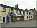
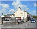
Royal British Legion, Whalley Road, Clitheroe
This is a social club rather than an operational site of the charity.
Image: © Stephen Craven
Taken: 23 Aug 2022
0.04 miles
10
Holmes Mill
This former weaving mill is now home to a brewery, the Bowland Beer Hall, a food hall, bakery and gelateria and will soon be hosting a hotel. It is a successful reuse of a textile mill that was working into the 21st century and was packed on a Saturday evening. The mill's 1910 built steam engine survives in a dining area but conservation needs to be addressed as it looks a bit 'rough'. Plenty of craft beers to choose and food was acceptable in my opinion.
Here's an earlier view - Image
Image: © Chris Allen
Taken: 9 Sep 2017
0.05 miles