IMAGES TAKEN NEAR TO
Wordsworth Drive, BLACKBURN, BB6 7JR
Introduction
This page details the photographs taken nearby to Wordsworth Drive, BB6 7JR by members of the Geograph project.
The Geograph project started in 2005 with the aim of publishing, organising and preserving representative images for every square kilometre of Great Britain, Ireland and the Isle of Man.

There are currently over 7.5m images from over14,400 individuals and you can help contribute to the project by visiting https://www.geograph.org.uk
Image Map (Loading...)


Getting Data...Please wait
Leaflet Map data © OpenStreetMap
Images are licensed for reuse under creativecommons.org/licenses/by-sa/2.0
Notes
- Clicking on the map will re-center to the selected point.
- The higher the marker number, the further away the image location is from the centre of the postcode.
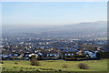
Image Listing (13 Images Found)
Images are licensed for reuse under creativecommons.org/licenses/by-sa/2.0
Image
Details
Distance
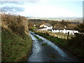
1
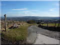
The western end of Great Harwood
Seen from the lane between Edge Side Farm and Belmont Farm. Hameldon Hill is in the distance.
Image: © Bill Boaden
Taken: 21 Jan 2011
0.08 miles
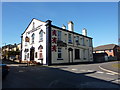
4
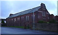
St Wulstan Roman Catholic Church, Rushton Street. Great Harwood
Image: © Robert Wade
Taken: 28 Nov 2009
0.22 miles
7
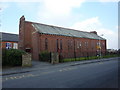
St Wulstan's RC Church, Great Harwood
Image: © Alexander P Kapp
Taken: 8 Mar 2011
0.23 miles
8
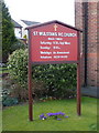
St Wulstan's RC Church, Great Harwood, Sign
Image: © Alexander P Kapp
Taken: 8 Mar 2011
0.23 miles
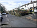
9
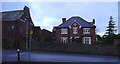
Presbytery of St Wulstan RC Church, Rushton Street. Great Harwood
Image: © Robert Wade
Taken: 28 Nov 2009
0.24 miles