IMAGES TAKEN NEAR TO
Sweet Briar Close, ACCRINGTON, BB5 5LZ
Introduction
This page details the photographs taken nearby to Sweet Briar Close, BB5 5LZ by members of the Geograph project.
The Geograph project started in 2005 with the aim of publishing, organising and preserving representative images for every square kilometre of Great Britain, Ireland and the Isle of Man.

There are currently over 7.5m images from over14,400 individuals and you can help contribute to the project by visiting https://www.geograph.org.uk
Image Map
Images are licensed for reuse under creativecommons.org/licenses/by-sa/2.0
Notes
- Clicking on the map will re-center to the selected point.
- The higher the marker number, the further away the image location is from the centre of the postcode.
Image Listing (12 Images Found)
Images are licensed for reuse under creativecommons.org/licenses/by-sa/2.0
Image
Details
Distance
1
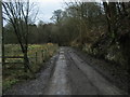
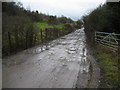
Access Lane beside Hyndburn Brook
Unmetalled access to light industrial premises beside Hyndburn Brook from the A680 Accrington Road.
Image: © Chris Heaton
Taken: 2 Feb 2010
0.07 miles
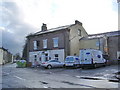
2
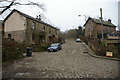
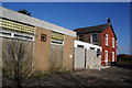
Printworks Cottages, Lower Barnes Street Clayton-Le-Moors
Taken at the junction of Lower Barnes Street and Holmes Road, looking back up Lower Barnes Street
Image: © Alexander P Kapp
Taken: 1 Feb 2006
0.09 miles
3
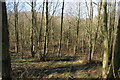
Woodland near Hyndburn Brook
Quiet woodland on the edge of Clayton-le-Moors where Hyndburn Brook runs through a small valley.
Image: © Bill Boaden
Taken: 2 Mar 2013
0.12 miles
4
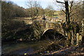
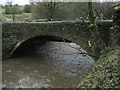
Hyndburn Bridge
An old bridge over Hyndburn Brook carrying the old route between Clayton-le-Moors and Great Harwood.
Image: © Bill Boaden
Taken: 2 Mar 2013
0.13 miles
5
Bridge over Hyndburn Brook
This bridge transports a wide muddy track over Hyndburn Brook beside Fiddler's Wood.
Image: © Chris Heaton
Taken: 2 Feb 2010
0.13 miles
6
Clayton Baptist Church, Sparth Road, Clayton-le-Moors
Image: © Alexander P Kapp
Taken: 13 Jan 2008
0.18 miles
7
Royal Oak, Sparth Road, Clayton-le-Moors
Image: © Alexander P Kapp
Taken: 13 Jan 2008
0.19 miles
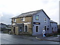
8
Forts Arms, Lower Barnes Street, Clayton-le-Moors
Image: © Alexander P Kapp
Taken: 13 Jan 2008
0.21 miles
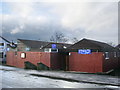
9
Park View Working Mens Club
The park, being Mercer Park, is hardly visible from here.
Image: © Bill Boaden
Taken: 2 Mar 2013
0.21 miles
10
Access Lane to Recycling Operation
Muddy access track leading from the A680 Accrington Road to a recycling operation, beside Hyndburn Brook.
Image: © Chris Heaton
Taken: 2 Feb 2010
0.21 miles