IMAGES TAKEN NEAR TO
Percy Street, ACCRINGTON, BB5 4LY
Introduction
This page details the photographs taken nearby to Percy Street, BB5 4LY by members of the Geograph project.
The Geograph project started in 2005 with the aim of publishing, organising and preserving representative images for every square kilometre of Great Britain, Ireland and the Isle of Man.

There are currently over 7.5m images from over14,400 individuals and you can help contribute to the project by visiting https://www.geograph.org.uk
Image Map
Images are licensed for reuse under creativecommons.org/licenses/by-sa/2.0
Notes
- Clicking on the map will re-center to the selected point.
- The higher the marker number, the further away the image location is from the centre of the postcode.
Image Listing (34 Images Found)
Images are licensed for reuse under creativecommons.org/licenses/by-sa/2.0
Image
Details
Distance
1
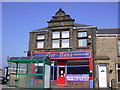
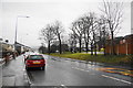
Ger Hana - Restaurants, 411 Blackburn Road Oswaldtwistle
Later re-named "West End Convenience Store" was originally the Co-Op
Image: © Robert Wade
Taken: 19 Mar 2009
0.03 miles
2
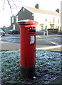
George VI postbox on Blackburn Road, Oswaldtwistle
Postbox No. BB5 275.
See Image] for context.
Image: © JThomas
Taken: 26 Nov 2016
0.05 miles
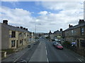
3
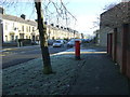
Blackburn Road, Oswaldtwistle
Showing position of Postbox No. BB5 275.
See Image] for postbox.
Image: © JThomas
Taken: 26 Nov 2016
0.05 miles
5
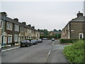
New housing development on Blackburn Road
The new houses, with open woodland in front, were built on the site of a former dairy.
Image: © Bill Boaden
Taken: 15 Jan 2011
0.08 miles
6
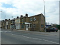
Former The Spread Eagle
Was a public house 50 odd years ago, now a Chinese Restaurant.
Image: © Alexander P Kapp
Taken: 16 Apr 2012
0.08 miles
9
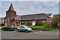
West End Methodist Church, Oswaldtwistle
Founded as West End Wesleyan Methodist Church before 1911 (it is shown on the OS map of 1911 https://www.old-maps.co.uk/#/Map/373290/428286/12/100674 but not that of 1894).
Image: © David Dixon
Taken: 12 Sep 2020
0.11 miles
10
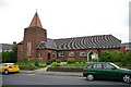
West End Methodist Church, Oswaldtwistle
Image: © Alexander P Kapp
Taken: 8 Sep 2005
0.11 miles